

You’ve just landed upon one of the most popular and challenging day hikes around Phoenix as well as the Superstition Mountains themselves- the Flatiron hike.
If class 3 scrambles, route finding, and valley views get your adrenaline going, then it is your time to conquer Flatiron.
Any Arizonian who hikes will probably ask if you’ve done Flatiron when you meet them. I can’t tell you how many times I’ve been asked this. Because if you survived Flatiron, then you’ve established your “clout” in the hiking community and you can most likely conquer all other difficult trails.
Even though I can think of more difficult hikes, Flatiron is physically challenging and well worth the effort. You can continue on for another challenging peak, backpack for the night, or connect the trail deeper into the wilderness.
This post covers the details on hiking Flatiron via Siphon Draw Trail in the Lost Dutchman State Park as well as options to continue your adventure. Whether you want to scramble all the way up to the summit, or only hike to the Siphon Draw, I’m here to help guide you the way!
FLATIRON HIKE STATS
Distance: 5.5 miles RT
Type: Out and Back
Difficulty: Difficult
Elevation Gain: Approx. 2,582
Location: Superstition Mountains, AZ
Trailhead: Siphon Draw Trailhead #53, Lost Dutchman State Park
Dogs Allowed: Yes
Hours: 6 a.m. – 8 p.m.
Fee: $10 Entry Fee
Note: If you only want to hike to the Siphon Draw and back, the overall mileage will be less than 5.5 miles and you won’t climb nearly as much elevation. From the trailhead to the Siphon Draw the hike is rated easy.

HOW TO GET TO FLATIRON VIA SIPHON DRAW TRAILHEAD
This hike begins within the Lost Dutchman State Park which requires a $10 fee per car. You’ll want to embark on the Siphon Draw Trailhead which will bring you into the basin called Siphon Draw. From there you can continue on to the Flatiron Trail which is where you begin to scramble to the summit.
Lost Dutchman State Park is roughly 40 minutes East of Phoenix near Apache Junction. I highly suggest grabbing a map when you go through the entrance for it has the trailheads, parking lots, restrooms, and roads all mapped out within the park.
Once through the entrance, you’ll follow the main park road and keep left to loop around past the Saguaro Day Parking. There is a parking lot for the Siphon Draw trail, but it fills fast. You can pretty much park anywhere between these two parking areas and hop on a trail to connect to the main one and be on your way!
I always recommend tracking yourself or following an already made track so you can check in and be sure you’re on the right path. Below is a screenshot of my track from Flatiron!

Preparation saves lives. Know where you are going ahead of time and always have a way to keep yourself on trail. One way to do this is with a GPS system or app.
You can download my Flatiron track and gain access to my library of all tracked hikes. Once downloaded, you can load it into your own trusty device for ease of mind!
*Disclaimer: the below links may contain affiliate links, which means I may receive commissions if you choose to purchase through my links I provide (at no extra cost to you). Please see my disclosure for more info.

WHEN TO HIKE FLATIRON
The best months to hike in the Superstition Mountains are November – March because the temperatures will be much cooler.
I will never suggest hiking Flatiron during the summer. Direct sun exposure paired with the summer heat can be dangerous. Especially since this hike is difficult and requires strenuous scrambling.
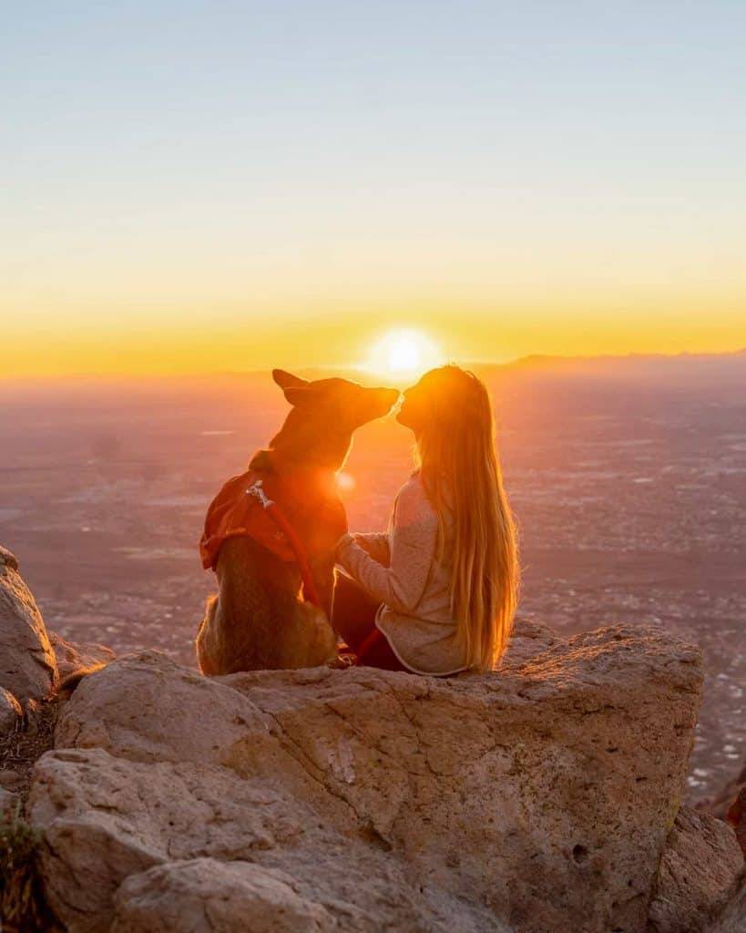
Since the trailhead begins from the State Park you’ll want to arrive early in the morning to secure parking and give yourself plenty of daylight to adventure. If you’re a sunset lover you’ll be happy to hear that Flatiron has a great view for sunset, and it is my favorite way to hike this summit!
HIKING FLATIRON FOR SUNSET
Flatiron is a great sunset hike if you’re brave enough to scramble down under the moon light. The summit faces West so you get unobstructed views of the sun going down in the distance. Not many people choose to do this, so chances are high you’ll have the place to yourselves!
I suggest beginning the hike 2.5-3 hours before the sunset time. If you know you’ll move at a slower pace give yourself an extra 30 minutes for some wiggle room.
You’re probably wondering how dangerous it is to scramble down in the dark, aren’t you? Let me tell you…it wasn’t as bad as I thought.
The trick is to begin hiking just before the last bit of light disappears so you can find the point which you begin the scramble down, and get the hardest climb out of the way.
From there it is pretty easy going. Just take your time, use a trusty headlamp, and always track yourself on a GPS app such as Gaia.
TIPS ON HIKING THE FLATIRON SUMMIT
- Use a reliable hiking pack
The Flatiron trail is rocky and requires climbing, so having a good hiking backpack to carry your supplies and keep your hands free is recommended.
- Pack plenty of water and snacks
This is still the desert, so it is highly suggested that you pack a minimum 2 liters per person for this hike. Using a hydration bladder makes it easier to sip water as you’re moving, plus it reduces the amount of water bottles you’ll need to bring along.
Climbing Flatiron brings on the appetite so don’t forget your salty and protein filled snacks. Rise Bars are my favorite protein bars to bring along on hikes!
- Bring hiking/climbing gloves
Once you begin scrambling there are a lot of loose desert plants, dirt, and slippery rock. It is always nice to have better grip and protection!
- You’ll want sturdy shoes with good grip!
Even if you’re hiking to just the Siphon Draw you’ll want great grip because the rock is very slippery at that point. There are also sections of loose rock while scrambling to the summit, and having a quality hiking shoe like the Adidas Terrex makes a difference.
- Bring layers
You’ll most likely warm up at the parts where you climb but it can get cold and windy at the summit. I like to always pack my packable down jacket in the colder months to stay warm and break the wind.
- Don’t wear loose fitted clothing for it gets caught on everything as you’re climbing.
- Watch for falling rock from others above. As people ahead of you climb they knock rocks loose.
- Hike with a partner or in a group for it is safer with this strenuous of a hike.
- Remember to Leave No Trace
Part of responsibly recreating in the outdoors is knowing and following the Leave No Trace Principals. It is imperative we all follow the principals so we can continue to visit these destinations and keep the environment in tact for future generations to enjoy.
Learn more about Leave No Trace.
RECOMMENDED GEAR FOR FLATIRON:


TIPS FOR DOGS HIKING FLATIRON
Some dogs can make it up Flatiron while others don’t have the experience, aren’t capable, or just flat out don’t like climbing. And that is okay!
Leave your dog behind if they’re not a good climber or you can’t lift them 5+ feet. There are several parts they may need an assist. This is a tough climb for humans and dogs included.
For those dogs who want to tackle Flatiron, below are my tips for a smooth adventure:
- If your dog wears a backpack make sure it allows them full mobility to climb
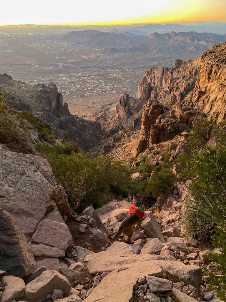
Monty wore his Ruffwear pack on this trail which is lightweight, allows full mobility, and is durable. It has a heavy duty handle on top which came in handy for assisting.
- Use a sturdy harness if your dog doesn’t wear a pack
Having that extra grip and support on your dog makes climbing and assisting much easier and safer. The Ruffwear Harness is designed for hiking dogs with durability and comfort in mind.
- Bring dog boots incase of paw injury.
You know your dog best, so it is up to you whether they wear boots to climb or not. Regardless, I suggest ALWAYS having a pair of dog boots and socks with you in the event of paw injury. The socks will help with blistering and keep the boots tight and snug.
- Pack plenty of water and snacks
Dogs have needs just as we do. Be sure to bring along enough water for them and a snack for the top too!
- Listen to the signs your dog gives!
Our dogs are smart and usually are giving signs regarding their needs. Pay attention to see if they’re getting exhausted, have an injury, or need extra water. It is best not to push them too far to their limits, and remember it is okay to have to turn back.
RECOMMENDED GEAR FOR DOGS:


For more on hiking with your dog visit Hiking with dogs- 10 essentials you should pack
HIKING FLATIRON VIA SIPHON DRAW
Once you’ve found parking it can be difficult to find exactly where the official trail begins unless you’re specifically at the Siphon Draw parking lot. This is why I always suggest using a map or GPS app that shows the trail systems so you can find where to hop on at.
Usually you can find a sign in the state park that points you in direction to the Siphon Draw, which is where you want to head.
For the beginning of the hike you’ll actually be on trails/roads that go through the Lost Dutchman State Park and pass by a few camping spots.
After a while you’ll weave through a cattle gate which indicates your entrance into the Tonto National Forest and marks the beginning of a big adventure ahead.
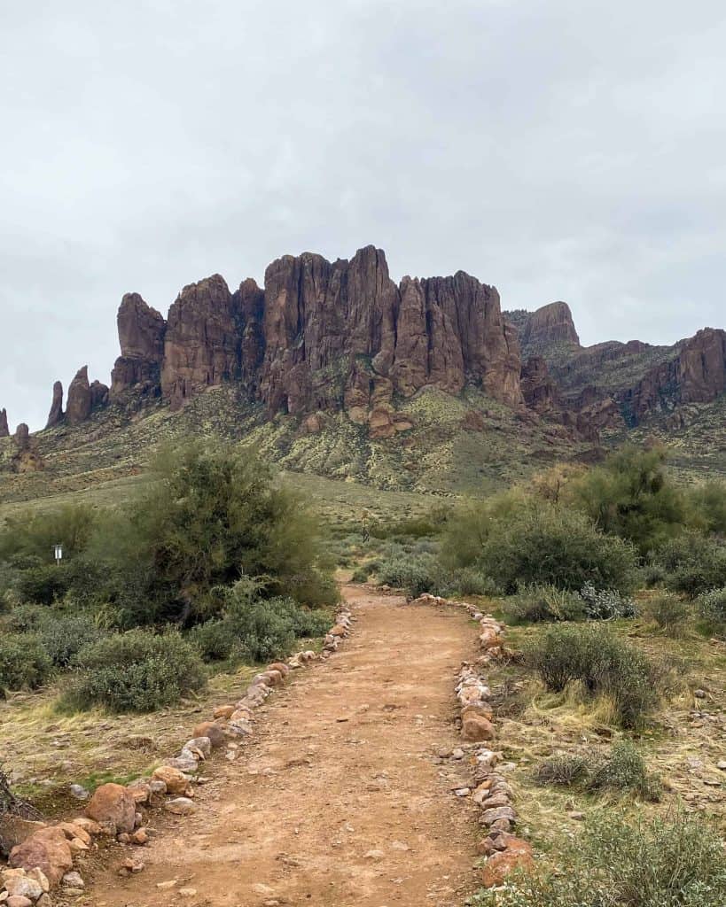
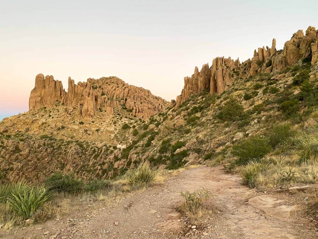
The trail to the Siphon Draw is very rocky, exposed to the sun, and gradually climbs in elevation. You can actually see Flatiron off in the distance as you hike towards it. It is the flat rock outcropping that resembles the bow of a large ship.
From afar it looks like a long and difficult trek which at times can be discouraging. But we aren’t thinking about that quite yet! Focus on making it to the Siphon Draw first, and then the real fun begins.
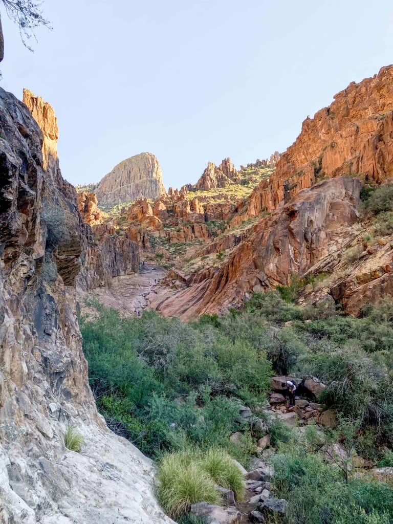
In roughly 2 miles you’ll reach the slippery Siphon Draw. Depending on recent rainfall the sloped rock will be either dry or wet with a stream running down it. Either way, the rock is still steep and slippery, so take your time on this part.

If there has been recent rainfall you may witness a small waterfall tucked in a corner off the trail. It will be on your left side and you can’t miss it…unless of course it is dry.
Some hikers take a break at this point since the large canyon walls provide shade and a good resting place before beginning the true climb. Others choose to turn around and head back to Lost Dutchman State Park.
If you choose to conquer Flatiron all you have to do is continue climbing up the Siphon Draw. The trail for the most part disappears since you’re climbing rock from here on up, but there are a couple pointers I like to give.
First, once you begin climbing there is a part where you can choose to go left and climb up large rocks, or stay lower to the right and hike through some greenery I like to refer to as a “little oasis”. This part is pretty obvious once you see it. You can continue on either way, but staying to the right is much easier especially if you’re hiking with your dog.
Once past the the little oasis you’ll keep climbing elevation and find your own path. Route finding skills will come in very handy the rest of the way. Land slides are always shifting the trail but as long as you know what Flatiron looks like and where you are headed, you’ll make it!
My second tip is to try to KEEP LEFT while in the canyon when it makes sense to. This probably won’t make sense until you’re actually hiking, but keep it in the back of your head.

Third, there is the “final climb” that looks like an almost impassable 10 foot rock wall. This is a major turning point for some people and dogs. If you can’t pass if yourself, or your dog can’t pass it, it is okay. You have to remember that you still have to come down which is sometimes even more difficult.
What I did the last time I hiked Flatiron was stick to the left of this wall and climb up. It was more narrow, but not nearly as high of a climb or as difficult. Monty barely needed any assistance but I held onto his harness for my own piece of mind incase he slipped.
Once past the final climb it is easy going to the summit! You’ll hike upon a saddle and a fork in the trail. Turn right to head to Flatiron. The summit is pretty flat and open, just awaiting exploration.


From the top you have expansive views out into the Phoenix valley and if hiking for sunset you’ll have an unobstructed view. There are plenty of places to spread out from the crowd and sit down to take in the views. Or at this point rest your legs because let’s be honest… that climb is a killer.
Once you’re ready to hike back down just head back the way you came. Remember going down can be even more tricky so take your time and be safe!
Craving more adventure? Keep reading for ways to extend your hike deeper into the Superstition Mountains.
CONTINUE YOUR ADVENTURE!
The trail systems in the Superstition Mountains are vast, providing endless trail connection opportunities. From Flatiron there are two main options and I’ve listed them for you below.
SUPERSTITION PEAK 5024
Just beyond Flatiron is Superstition Peak 5024, another difficult peak to conquer within the Superstition Mountains. Both can easily be hiked in the same day, and even though Peak 5024 doesn’t add too much more in distance, it is another leg burner and difficult to follow.
You will need a map and an extra couple hours to summit this one, but if you’re up for the challenge it will be well worth it! From the top the views are even better than Flatiron and you gain a cool perspective looking down onto Flatiron itself.
SUPERSTITION RIDGELINE TRAIL
Another option is to extend your hike along the Superstition Ridgeline Trail where you can backpack for a few nights or connect your hike all the way to the Hieroglyphic Trail, or even further to the Wave Cave, making for a super long day.
Yes people have done this, and yes it is on my list! All you have to do is have 2 cars to park at either trailhead and shuttle back and forth.
Take a look at this route on a map and head out prepared for anything, though. This trail is very hard to follow and overgrown in areas. I only suggest this to the very experienced hikers and outdoorsy adventurers.

FINAL THOUGHTS ON HIKING FLATIRON
I’ve hiked Flatiron twice now and after doing it at sunset I have to say I don’t want to do it in the morning ever again. Sunset on the summit was magical!
Hiking down in the dark was challenging yet enjoyable because there were no other hikers on the trail. The sky was bright from the moon and the temperatures were comfortable even without the sun. This sunset hike has made it on my list of all-time favorite hikes I’ve done yet.
Flatiron is always challenging and rewarding. If you’re considering conquering it, I say go for it! But listen to your body, your dog, and know your limits. It will be easier for some of us than others. If this hike is something you have to work towards, that is okay. If you have to turn back or it takes you multiple attempts, that is okay too.
But I can guarantee once you do summit Flatiron, it will make it to the top of your favorites list too!
More in the Superstition Mountains:
- Massacre Falls | A magical waterfall in Phoenix’s Superstition Mountains
- Hike Battleship Mountain via. First Water Trailhead
- How to find Broadway Cave in the Superstition Mountains, AZ
- Weavers Needle Loop Trail in the Superstition Mountains
You may also enjoy:
- Dolly Steamboat Cruise- the best way to experience Canyon Lake
- 5 of the best Sedona Caves and how to find them
- How to Hike to Humphrey’s Peak- Arizona’s Tallest Peak
- The Crack at Wet Beaver Creek- Arizona Swimming Hole
That looks like it was a really fun experience! I love hiking also because of the views you see and the people you meet! I will definitely add this to the list of things to do when we make it down to Arizona!
Hi Kathrine! I agree, you can get some of the best views from hiking and meet some of the best people! I hope you enjoy your next visit to AZ. Thanks for reading!