

Boynton Canyon’s Subway Cave has grown in popularity the past several years, and understandably so. It is one of the best Sedona Hikes to visit and photograph due to the unique curvature and nerve-wrecking opening down the middle.
Visitors from all over the world travel to hike to this cave, and yet many end up not being able to find it for they missed the unmarked spur trail that leads to it (it is very easy to miss)!
If you’re trying to figure out how in the heck you can find your way to the Boynton Canyon’s Subway Cave without getting lost then don’t go anywhere. I’ll guide you through the important hike details such as exact turning points, stats, and more tips. By the end you should have no problem finding it yourself!
This cave is 1 of 5 amazing caves within the Sedona Wilderness I’ve hiked to. Check out 5 of the best Sedona Caves and how to find them for more!
Treat It Like Your Own!
UPDATE 10/10/23
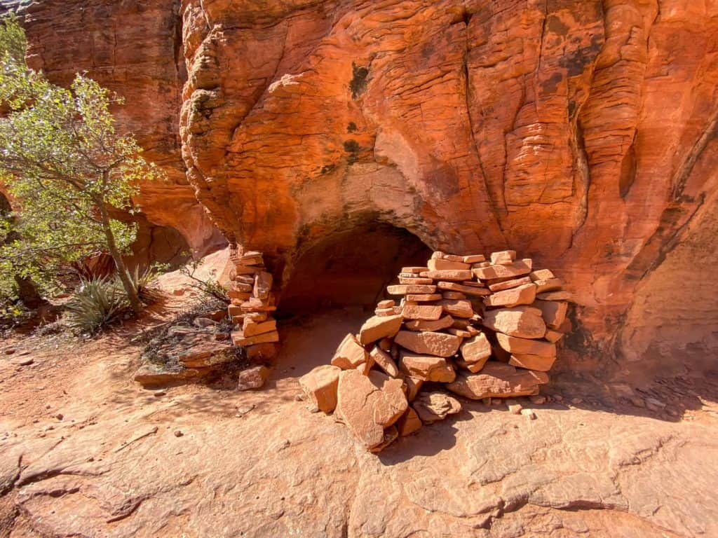
Recently a visitor went to a nearby dwelling site and knocked over one of the walls. It should go without saying that damaging and vandalizing archeological sites is illegal, but it also is extremally hurtful and disrespectful to the Indigenous communities and their culture. Sedona is a special place full of history that cannot be rebuilt or replaced, and recent events have caused quite a stir in the local community- rightfully so.
I believe everyone should have access to public lands but we must do so carefully and with respect. In order to continue to have access to places like the Subway Cave and preserve it for future generations we must take care of them. If we don’t tread lighting we surely will begin to see access revoked in attempt to end the littering and vandalism that takes place.
Please, help keep these beautiful destinations like the Subway Cave open by learning and practicing the Leave No Trace Principles.
- Plan ahead and prepare.
- Travel and camp on durable surfaces.
- Dispose of waste properly.
- Leave what you find.
- Minimize campfire impacts.
- Respect wildlife.
- Be considerate of other visitors.
Additionally, archeological sites are not to be touched or leaned on. Please do not carve in the rocks, remove the rocks, or take artifacts.
These principles have been created in hopes to minimize the impact our outdoor spaces endure and protect sensitive areas. Thank you for being a good outdoor steward and following them!
Boynton Canyon Trail Stats
- Hiking Distance | 6.0 miles
- Difficulty | Moderate
- Elevation Gain | 668 feet
- Total Time | 2.5-3 hours
- Permits/Fees | Red Rock Pass or National Parks Pass
- Trailhead | Boynton Canyon Trailhead
- Dog Friendly | Yes
Below is a map of the route to the Boynton Canyon Subway Cave.


These stats are measured from the Boynton Canyon Trailhead to the Subway Cave and back. The Subway Cave turn off is before the end of the Boynton Canyon Trail. While there isn’t a “destination” at the end of the trail, you can finish it if you’d like. Just remember that it will add some distance to your hike!
How To Get To The Boynton Canyon Trailhead
The hike to Sedona’s Subway Cave begins at the Boynton Canyon Trailhead. Feel free to map it from the link or follow the directions below. You will want to arrive early on weekends and during peak seasons because the parking lot fills up fast.
The trailhead is a 17 minute drive from the heart of Sedona. Leaving from Sedona, you’ll get on 89A heading west, through West Sedona. Turn right on Dry Creek Road and follow it for a few miles. You’ll pass Devil’s Bridge Parking area, then soon after intersect with Boynton Pass / Long Canyon Road.
If you turn left you’ll head down Boynton Pass, which is where you want to go. Follow this road for a couple more miles until it curves, and on the right hand side, right as it curves, you will turn right into the Boynton Canyon Trailhead parking lot!
Sedona Shuttle System
Due to traffic congestion the city of Sedona has implemented a free shuttle system. This typically runs from Thursday-Sunday and on select holidays. The shuttle services the popular trailheads during busy times and the trailhead parking may be closed while the shuttle is operating. You can visit the Sedona Shuttle Website for more information.
Currently you do not need to use the shuttle to reach Boynton Canyon Trailhead, and the parking lot remains open!

When To Hike The Boynton Canyon Trail
Hiking in Sedona can be done year round but the city does reach extremely high temperatures and sees crowds of visitors each year. I’m positive you can make the most of your visit no matter when it is, but below are some suggestions if you have the flexibility to choose.
Best Seasons For Hiking In Sedona
Spring, fall, and winter are the most comfortable times to hike in Sedona. Spring and fall offer peaceful, chilly mornings, then typically heat up late morning – midday. Always check the weather for some weeks can have heat waves and will still be 90 degrees!
Spring and fall are peak times for hiking in Sedona, so plan on getting an early start to beat the crowds. What I mean by early- begin hiking just before or right at sunrise.
Winter will have colder mornings and won’t be as busy, so you can get a later start. If you’re lucky you may get a dusting of snow on the ground too! Most hikes, like the Subway Cave off Boynton Canyon Trail, can still be done in the winter as long as the area didn’t get slammed with a snow storm.
It is never recommended to hike in the middle of summer, especially midday. If you are bound and determined to hike in the summer, make sure you begin just before sunrise and end by late morning.
Best Time Of Day To Hike In Sedona
If you aren’t an early riser then now is the perfect time to start! When hiking in Sedona it is best to begin just before, or right at sunrise (except for during the winter). The parking lots fill up fast, crowds can get large, lines form at the cave, and you may not get the experience you set out to seek.
Some trails are good for sunset, however if you want to visit the Boynton Canyon Trail’s Subway Cave, it has its best light inside the cave during morning-afternoon.
Preparation saves lives. Know where you are going ahead of time and always have a way to keep yourself on trail. One way to do this is with a GPS system or app like Gaia GPS.
You can download my Boynton Canyon Cave track and gain access to my library of all tracked hikes. Once downloaded, you can load it into your own trusty device for ease of mind!

Hiking The Boynton Canyon Trail To Subway Cave
From the parking lot you’ll want to head back up towards the road, and on the right side you will find the Boynton Canyon Trailhead directly across from the vault toilets. There will be a sign for the Red Rock Secret Wilderness as you enter the Coconino National Forest.
At first there are a couple intersections you’ll hike upon but if you follow the signs to keep on the Boynton Canyon Trail you’ll be able to navigate just fine.
Overall the hike along the trail is easy. For those who don’t hike as often they may find it more moderate especially with the longer distance. You’ll come upon the usual rock steps and inclines, but for the most part the trail is flat in the beginning.


For the majority of the way the Boynton Canyon Trail leads you behind the Enchantment Resort. It feels as if you are hiking through their backyard at times and it turns some hikers off since it doesn’t feel like you’re lost in the wilderness. I know I certainly wasn’t expecting that, but I just kept my eyes peeled ahead to the beautiful views.
Just before you hike behind the Enchantment Resort you’ll pass a turn off that will lead you to the Boynton Canyon Vortex. It brings you up onto a rock outcropping where many people sit to take a break and soak in the energy. Feel free to visit it, then turn back and turn right to hop onto the Boynton Canyon Trail and head to the Subway Cave!
The Exact Turning Point To Find The Subway Cave
Because the Boynton Canyon Trail doesn’t lead you directly to the Subway Cave many people get lost and miss the turnoff for it. The trail actually continues for a while past the turnoff, but doesn’t take you to any “epic destination”. Although the sights are the end are still worthy of a visit.
If you’re wanting to see the Subway Cave you’ll have to turn right onto a spur trail, off the main trail. The Subway Cave will be 0.65 miles down the spur trail!
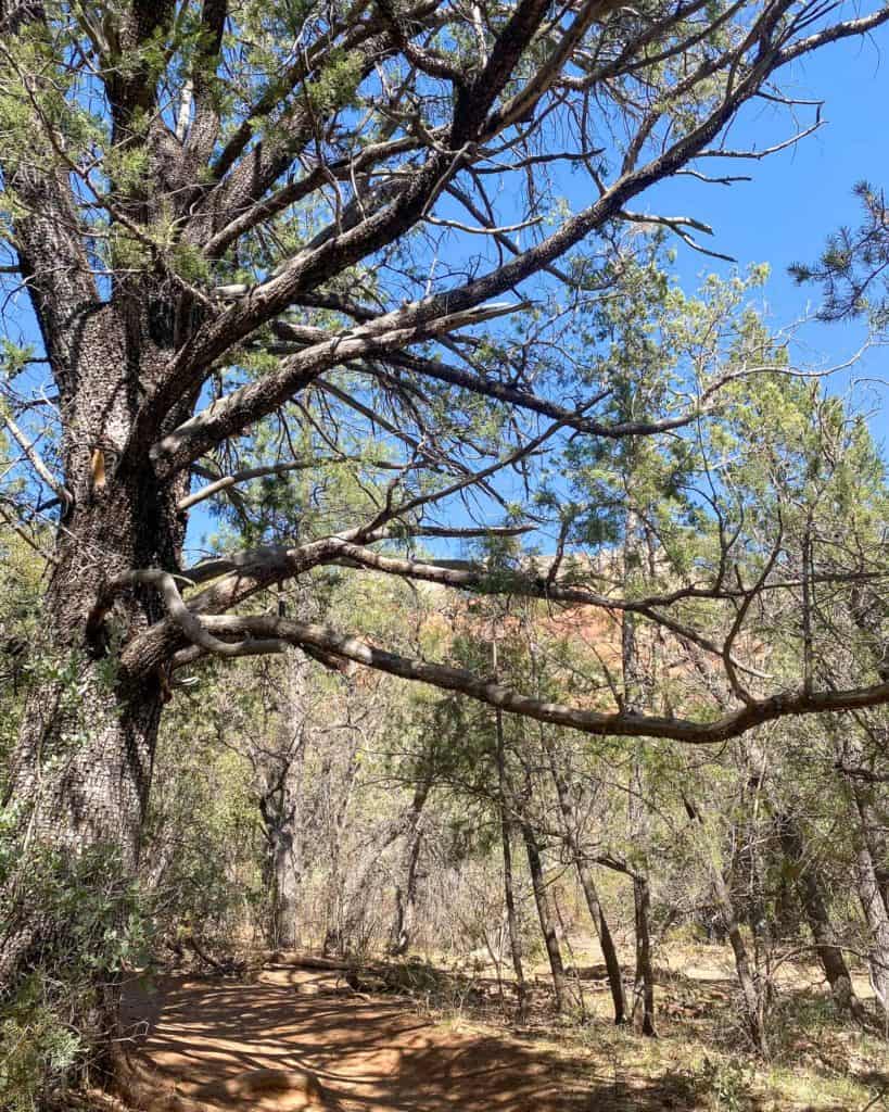
The turnoff to the cave will be about 2 miles from the trailhead. There will be an Alligator Tree (pictured below) on the left side of the trail, and up ahead on the right side of the trail will be a pile of sticks either leading or blocking the spur trail. It switches up from time to time because some people want to help you find it, while others don’t.
Just remember 2 miles in and you’ll need to turn right. After you hop onto the spur trail there will be another unmarked fork that can get confusing.
Roughly .18 miles along the spur trail and you’ll hike upon a creek bed and large stump (pictured below). This stump marks where you till take a hairpin like turn to the right, up a hill. Do not cross the creek bed!
Once up the hill, the trail is pretty easy to follow and will lead you straight to the cave and nearby native ruins.

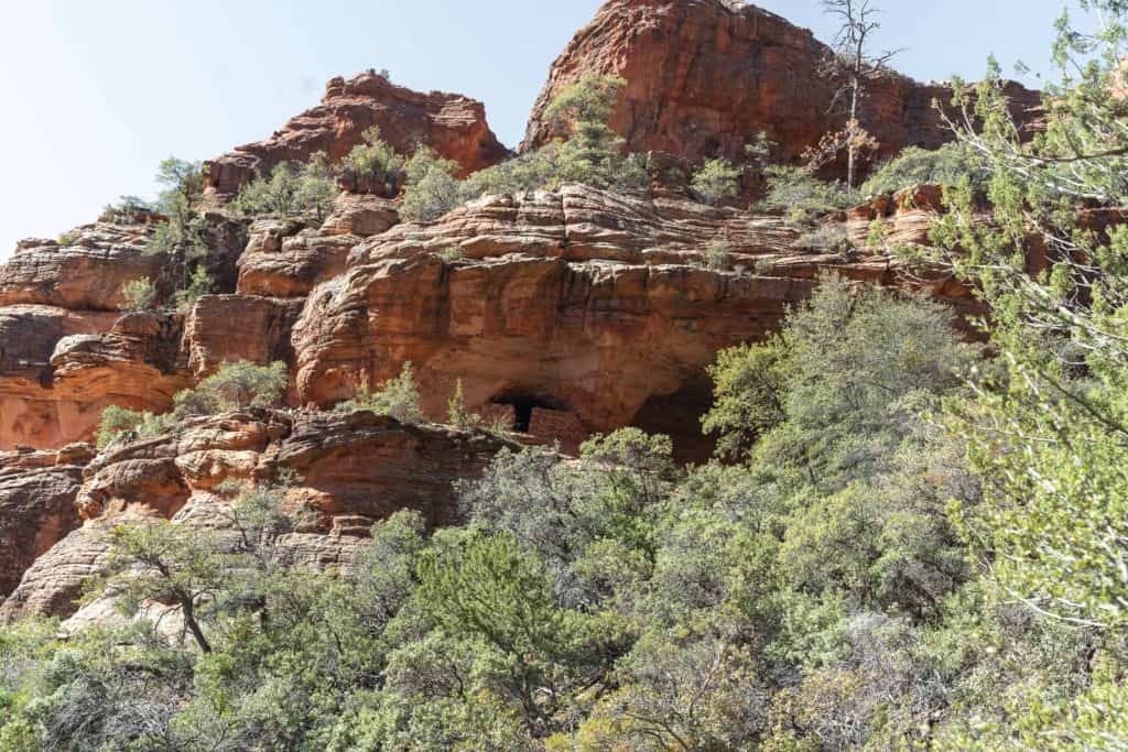
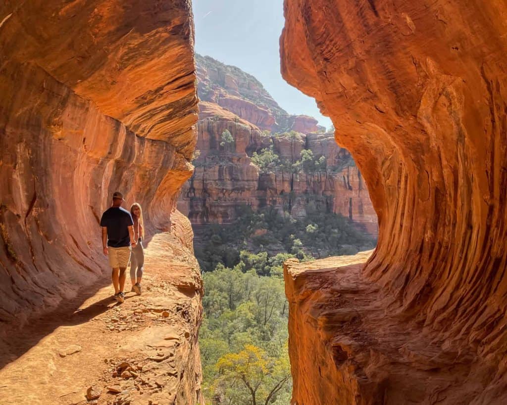
As you’re approaching your destination you’ll spot the Sinagua ruins up on the cliffside first. The Subway Cave can’t be spotted from a distance or even when you hike up to it. It is tucked back inside the red rock and to access it you will need to do a little scrambling. There are essentially two different approaches you can take.
The first approach would be to scramble from the bottom, up to the mouth of the Subway Cave. The Boynton Canyon Trail will dead end right at the base of the cave. There will be a very steep incline up slick rock and around desert foliage. Once inside the cave you walk to the back, turn around, and look out to get the full affect!
Most people take this approach not knowing about the second option. I do not recommend the first approach for it is a bit sketchy and frankly harder than it needs to be. Instead, look to your left and take the trail leading up to the Sinagua ruins.
Local History
The Sinagua’s inhabited the land around Sedona beginning around 650 A.D. for nearly 800 years. Their civilization grew corn, beans, and squash. They even had dogs as pets! Historians aren’t exactly sure why they left the land, but they do have some suspicions. Luckily they left behind some pottery, rock art, and ruins for us to appreciate and learn from. If you happen to stumble upon ruins in Sedona, chances are they are the Sinagua ruins left behind.
It is still a steep climb up to the ruins but it is on a rocky, dirt trail that is shorter and easier than scrambling at the base. This little trail will take you up to a ledge at the top. To view the ruins you’ll turn left and to get to the Subway Cave you’ll turn right.
The ledge has plenty of room for you to walk between the ruins and the edge, but when you get closer to the cave the ledge becomes pretty narrow. Hug the wall, take careful steps, and go slowly. You’ll make it no problem!
I decided to hang a left to view the ruins first. There are two ruins- a smaller one and larger one with the wall knocked down. It is very unfortunate that someone had to knock this wall down. If you visit the ruins please be respectful, don’t touch, and report any vandalism you may see others doing.
WARNING!
The Sinagua Ruins are considered historical and it is illegal to move, deface, or carve into these archeological sites. Please remember to practice the Leave No Trace Principles when visiting.

After viewing the ruins you can continue along the ledge for beautiful views into the Sedona wilderness, or, simply take the ledge back where you started and continue towards the cave. The ledge rounds a corner and does get a bit narrow so watch every step along the way.
Once you round the corner you’ll be able to view into the back of the cave. Walk all the way to the back and turn around to get the full Subway Cave affect! You can walk on either side of the cave, crossing from one to the other at the back end.

Sometimes there is a line to get into the cave but typically other hikers are considerate about waiting and letting each other take their pictures without photo bombing one another.
Once you’ve gotten your fill of the Subway Cave you can scoot down the first approach if you dare. If you’ve had enough adventure and want to play it safe, exit back the way you entered and take the ledge around to the ruins then back down the trail you came up.
What To Pack For Your Hike
Hiking Shoes:
Having a sturdy and reliable hiking shoe, not tennis shoes, makes all the difference. Typically I hike with my Adidas Terrex in the desert, but if it is chilly I choose to wear my Salomon X Ultra 4 Mid which is also a solid choice if you require extra ankle support!


Merino Wool Socks:
Moisture wicking socks are essential to prevent sweaty and blistery feet. They also are very warm and comfortable! I use Darn Tough Cushion Socks which are the perfect height to pair with boots and cover the heel, thus preventing blisters. If you like ankle height they have those too!

Hiking Backpack + Water Reservoir:
Any normal backpack will do, but a quality backpack like Osprey Skarab 30 with straps, support, and breathability will feel like luxury during this hike. It also holds a water reservoir which makes it easier to carry water and stay hydrated on the trail without having to stop.

Sun Protection:
This one is extremely important because in the desert the sun is almost always beaming. You should always pack sunscreen with you and apply it before setting out to hike. Coola is an organic sunscreen perfect for the outdoors. A hat, sunglasses, and a lip balm are also important sun protection items to carry.


Connect To Another Sedona Cave!
Birthing Cave
If you’re looking for a bit more adventure and want to visit another Sedona Cave, consider The Birthing Cave! It is one of the most photographed caves in Sedona and is even easier to get to. The pus side- you can connect from the Boynton Canyon Trail to this one. The Birthing Cave parking lot is extremely small so sometimes it is easier to just go on foot.
I highly suggest utilizing a map system if you choose to connect the hikes for that is how I figured out this route. I have not hiked it yet, however, so I do not know the distance between the two. My best guess is the connecting route is 1.5 miles, so 3 miles round trip. I drew this route in blue for you on the map below.

Let’s say you park at the Boynton Canyon Trailhead and hike to the cave, then back. Just before you get back to the parking lot, at the last trail intersection, you’d turn left onto Deadman’s Pass Trail. Hike until you intersect with the Long Canyon Trail and turn right. This trail will lead you to another intersection, which is the point where you’ll turn right to head towards the Birthing Cave.
There will be another point where you turn right, to climb up to the cave. For more detailed information on how to get there, check out my trail guide below!
Read: The Birthing Cave in Sedona- EVERYTHING you need to know

Final Thoughts On The Boynton Canyon Trail And Subway Cave
In all honesty I was impressed and loved photographing the cave, but as far as the hike itself goes I wasn’t too impressed. I hiked the Boynton Canyon Trail early one Saturday morning and beat the crowds. Still, I wasn’t a big fan of hiking behind the Enchantment Resort for what seemed like half the hike.
Seeing the Sinagua ruins in person was exciting, and the views from the ledge they sit on were stunning. Once the crowds of people began filtering in, though, I could see just how busy this place can get, making me want to leave. Once I began hiking back I passed several groups of hikers confused on how to find the Subway Cave.
I was happy to give them verbal directions as we passed, hoping they were able to make it and see the interesting cave for themselves. Hopefully this guide reaches you before you embark your own hike to the Subway Cave!
More in Sedona:
- Visit these 4 Sedona Wineries all in one day
- Hiking Cathedral Rock: All you need to know
- Hike to Devil’s Bridge in Sedona, Arizona
- Hiking A.B. Young Trail to East Pocket (Edge of the World)
- Hiking Vultee Arch From Sterling Pass Trailhead
I’d love to hear from you!
Have you hiked to the Boynton Canyon Subway Cave before, or is it going on your itinerary? Maybe this guide helped you find it? Share in the comments below.
Thanks Kara, wouldn’t have found it without your article. There were a few other people there when I got there but it was fun figuring out how to get up that more precarious approach together. Besides, isn’t that half the fun of travelling and discovering new places… meeting people from different cultures who share the same interests?
Hi Ben! Thanks for coming back to leave a comment. So glad you were able to find the Subway Cave 🙂 That is exactly part of what discovering new places is about…sometimes you end up meeting the most wonderful people and having memorable experiences. Keep in touch!
Hi Kara, great article! Do you have pictures of the second, lesser known approach to the cave? Like, where you take the left up to the Sinagua ruins?
Hi Namitha! I did not end up taking pictures of the other approach. However it is very evident where you need to go for there is a little trail- can’t miss it 🙂
This is so amazing to me!! Great information and tips, thanks for sharing!! I can’t wait to visit Arizona one day!!
Awesome pictures!!
Thanks so much Pat! Hope you do get to make it to AZ some day. There’s SO much to do and explore!
Hi Kata, amazing post! I have two questions – 1) when you say best lighting is morning-aftwrnoon, do you mean, say 8am-12 noon? What was the timestamp on your photographs? 2) Can you share a picture of the left taken for the 2nd approach to the cave?
Sorry, *Kara, that was a typo.
I will have to make sure to stop here next time we are in Arizona!! This looks incredible but I definitely understand not liking hiking by a resort half the time! Looks like the end result was worth it though!
The end was definitely worth it 🙂 Thanks for reading Kate, hope you get to visit soon!