

High-pointing each state is a goal for some adventurers, and if you’re interested in doing so in Arizona- Humphrey’s Peak will be your challenge.
Sitting at 12,633 feet above sea level, Humphrey’s is the tallest peak in Arizona, and as expected, one of the most difficult to summit. The entire area once was a single stratovolcano most commonly referred to as San Francisco Mountain. The mountain eventually collapsed, forming the peaks we see today.
In this post I’ve included Humphrey’s Peak directions, safety precautions, trail information, and more. It is a strenuous hike and I want to be sure you are well prepared before tackling this one!
HUMPHREY’S PEAK STATS
Distance: 11 miles RT
Type: Out and Back
Summit Elevation: 12,633 ft.
Elevation Gain: 3,300 ft.
Difficulty: Difficult
Location: Flagstaff, AZ
Trailhead: Humphrey’s Peak Trail
Dogs Allowed: Yes
*Disclaimer: the below links may contain affiliate links, which means I may receive commissions if you choose to purchase through my links I provide (at no extra cost to you). Please see my disclosure for more info.
HOW TO GET TO HUMPHREY’S PEAK
You can map your directions from here or follow the directions below!
Starting from Flagstaff you’ll head North on Hwy 180 and turn right onto N Snow Bowl Rd. If you follow GPS directions or signs to the Arizona Snowbowl it will take you to the right place!
Continue along the windy road for about 6.5 miles and you’ll arrive at the Arizona Snow Bowl. There will be large dirt parking lots on your left where you’ll park. There is a path that leads you across an open meadow and under the ski lifts to the trailhead within the forest. Overall it is super easy to find!

WHEN IS THE BEST TIME TO HIKE HUMPHREY’S PEAK?
The best and most popular time to hike Humphrey’s Peak would be in the fall right after the summer monsoon season and right before winter hits. October is the area’s most populated month because the Aspen’s turn a stunning yellow.
If you choose to hike in the winter you can expect a lot less people but have to deal with cold temperatures, snow, ice, and wind.
Summer always seems like a nice time to hike, but that doesn’t apply in the Kachina Peaks Wilderness. You’ll want to start very early and be extremely cautious of mid-afternoon spontaneous weather changes and thunderstorms. At this elevation, the risk of getting stuck in a storm and struck by lightening is high, let alone the risk of forest fires.
Related: Check out Kendrick Peak, Arizona’s 2nd tallest peak!
Packing List
- The 10 Essentials
- Hiking Backpack
- Hiking Shoes
- 3L bladder
- Camera
- Headlamp
- Packable Jacket
- Lunch & Snacks
SAFETY CONSIDERATIONS + TIPS
- Thunderstorms, or monsoons, are most active during the summer months especially July and August. Pay attention to weather changes for they can change drastically with little to no warning. Being above tree line during a storm poses high risk. If hiking during the summer, begin very early!
- Hydrate the day before and during the hike. The air is pretty dry and it will help with hiking in high altitude.
- Know the signs of altitude sickness. If you feel like you’re being affected by the change in altitude, take a rest and drink water, then slowly descend back down the mountain. We all have our days!
- Pack layers for the temperature decreases as you ascend and it is very windy at the top.
I always recommend tracking yourself or following an already made track so you can check in and be sure you’re on the right path. Below is a screenshot of my track from Humphrey’s Peak!

Preparation saves lives. Know where you are going ahead of time and always have a way to keep yourself on trail. One way to do this is with a GPS system or app.
You can download my Humphrey’s Peak track and gain access to my library of all tracked hikes. Once downloaded, you can load it into your own trusty devise for ease of mind!
HIKING TO HUMPHREY’S PEAK
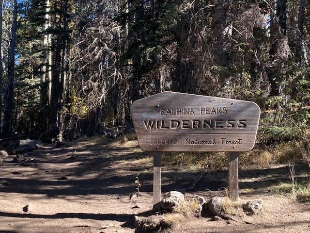
Once you walk through the big open meadow and under the ski lifts, you will come upon a sign for the Kachina Peaks Wilderness within the forest. This is where you enter and begin your trek up to Humphrey’s Peak.
The trail begins climbing elevation almost immediately. Expect the trail to be rocky, have exposed roots and the occasional fallen tree but overall in good condition.

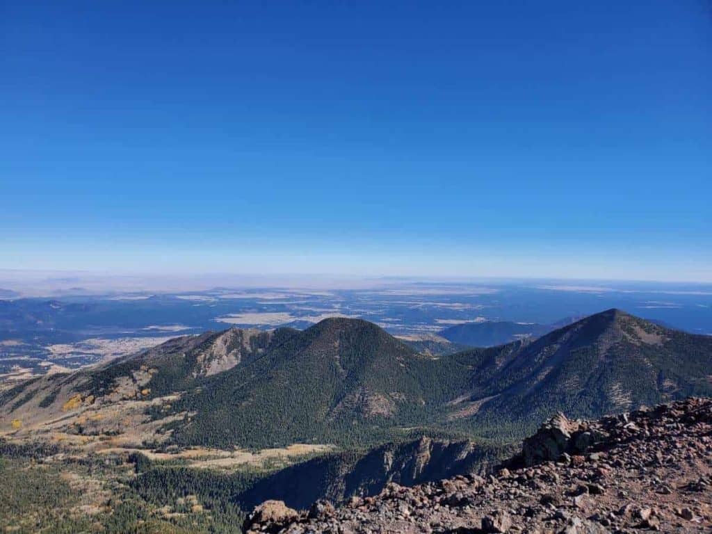
You’ll hike up a series of switchbacks, gaining elevation quickly under the tree line. As you ascend there will be clearings between the trees, providing beautiful views out into the wilderness.
The switchbacks end at the saddle which is a nice place to take a break. The views here are stunning as you can see the backside of the mountain into the Inner Basin.
To continue to Humphrey’s Peak from the saddle you’ll take a left up the ridge. If you hang a right it’ll lead you towards Agassiz Peak.

The hike along the ridgeline is considered strenuous. It is very steep, rocky, and windy. You’ll want to take it slow, be sure of your footing, and probably layer up!
Humphrey’s Peak is a bit further than you may think at this point. There are 3 false peaks and you can’t really tell until you get past one and see the next. It seemed like it took forever at this point because everyone was moving slower and the false peaks kept playing tricks on us!

You’ll know you’ve reached Humphrey’s Peak because it is the very last peak along the ridgeline headed that direction. There also is a sign you can take a picture next to and rock walls built up to barricade yourself from the wind and eat your lunch.
Welcome to the tallest peak in Arizona! The views span for miles in each direction. Once you’ve gotten your fill of views and your picture with the sign you’ll head back down the way you came.


NEARBY HUMPHREY’S PEAK
ARIZONA SNOW BOWL
Humphrey’s Peak Trail begins from the Arizona Snow Bowl Ski Resort! During the fall season this area turns golden yellow and is a destination for photos, hiking, and simply getting out to walk and see some fall colors.
The ski lifts are usually closed if it isn’t ski season, but for a brief time during fall Arizona Snow Bowl sells Scenic Chairlift Tickets so you can ride the lift for some amazing views of the changing trees and surrounding mountains. Be sure to look up their schedule and purchase tickets ahead of time!
FREIDLEIN PRAIRIE DISPERSED CAMPING
If you plan on camping in the area definitely consider Freidlein Prairie Dispersed Camping. It is the closest “campground” to Humphrey’s Peak. There are no services available but there are 14 camping sites which are free!
LOCKETT MEADOW CAMPGROUND
Although it is a bit of a drive to the other side of the mountain, Lockett Meadow Campground is another option for camping. Deep in the Aspens, this area is an autumn lover’s dream! You can also hike to Humphrey’s Peak from here, but it is more strenuous and will total roughly 14 miles round trip.

FINAL THOUGHTS ON HUMPHREY’S PEAK
My body may have been hurting near the end of this hike, but looking back on the experience and remembering that “oh, wow!” moment while looking out at the epic views, I’d have to say it was worth every step.
Humphrey’s Peak was challenging yet rewarding- exactly something you’d expect from the tallest peak of any western state. It definitely takes some determination and prior preparation, but this hike is one to remember.
More in Arizona:
- East Pocket (Edge of the World) Camping
- How to find the Soldier Pass Cave- Sedona
- Hiking A.B. Young Trail to East Pocket
You may also like:
- 11 of the Best Salt Lake City Hikes
- The most epic Utah Road Trip Itinerary for 7-10 days
- Hiking with your dog- 10 essentials to bring