
Hiking from Rim to Rim in the Grand Canyon National Park is a monumental endeavor thousands of people set out to accomplish each year. While it is an amazing experience it’s also the most difficult hikes you can add to your bucket-list. But, from experience, I can say every step is worth it.
I’m talking deep canyon drop offs, fresh water streams, seasonal waterfalls, bridges, and tall box canyon views along the way.
Before setting out to cross the entire width of the Grand Canyon a level of preparation is necessary. It is important to understand the canyon itself is unforgiving.
In this guide we’re going to cover your options for hiking or backpacking, how to plan your trip, where to stay, transportation, what to pack, and what to expect during the hike.
We’re going to cover a lot but after following this guide I feel confident that you’ll be well prepared for Rim to Rim! Feel free to use the table of contents below to skip to different portions if needed. Now let’s get to it!
Pssst- if you want to skip all of the planning information then click here to jump to the trail guide!
Hey there! Just so you know the below links contain affiliate links, which means I may receive commissions if you choose to purchase through my links (at no extra cost to you). You can visit my disclosure for more info.
What Is Rim To Rim?
The Grand Canyon is a large chasm carved out by the Colorado River thousands of years ago. The chasm is 277 miles long in total and up to 18 miles wide at parts with an average depth of 1 mile. The Colorado River still runs through it today, though not as powerful as once was.
For visitation purposes the National Park is separated into North, South, East, and West entrances. In order to hike Rim to Rim you’ll begin on the North Rim and hike to the South Rim or vise versa by using the main corridor trails. The hike is anywhere from 21-26 miles total depending on which route you take and if you add in any extra stops.
Some people hike this in a single day while others break it up into two days by backpacking it. We’ll break down the pro’s and con’s of each later in this post.
Nervous about the mileage? I suggest conquering How To Hike South Kaibab, Phantom Ranch, & Bright Angel In One Day first!
Which Direction To Hike The Grand Canyon Rim To Rim
So, which direction should you hike- North to South or South to North?
A lot of logistics and planning will influence that decision- like where you’re able to actually book lodging, what direction you are arriving to the park from, etc.
But if you are able to choose based on statistics alone you may be interested in the comparison chart below. These are the two most common routes:
| North To South | South To North |
| North Kaibab Trail to Bright Angel Trail | South Kaibab Trail to North Kaibab Trail |
| 24 miles | 21 miles |
| 5,570 feet total ascent | 6,200 feet total ascent |
| 10-15 hours | 9-13 hours |
| Several lodging & food options at end | Limited lodging & food options at end |
| Water along entire route | No water access for first 7 miles |
| Plenty of restrooms | Plenty of restrooms |
| Hike from colder to warmer temps | Hike from warmer to colder temps |
As you can see each direction has it’s pro’s and con’s, but hiking South Kaibab to North Kaibab may be the better route for your first time. This way you’ll be on your feet for less miles and hours which makes a huge difference near the end. You do climb more elevation but it is more gradual than when climbing up Bright Angel, and if we’re being honest the climb out is difficult no matter which way you go.
On the flip side it was really nice for my group and I to end our journey and leave from the South Rim since it is a closer drive to Phoenix. We wanted to leave the park as soon as we reached the rim. So this logistical fact helped us decide to hike North Kaibab to Bright Angel.
No matter which direction you hike Rim to Rim one thing is certain- it is going to be a challenge!
2 Ways To Complete Rim To Rim

Now the question is whether you are going to attempt to complete this major hike in a single day or take it slower and backpack it. Both have their upsides and downsides and sometimes we don’t get to make the choice- the lottery permit system does it for us.
Let’s break them down below.
1. Day Hiking Rim To Rim
Most people set out to complete Rim to Rim as a day hike and they have all of my respect for being able to do so. It is an extremely difficult hike not only due to the elevation gain but because of the mileage involved, the hours on your feet, and the lack of resources down in the canyon. Here are some other things to consider:
- Hiking this in a single day is extremely dangerous if you are not experienced, have the proper gear, or trained for it.
- You’ll be hiking all of the mileage in one day and won’t have time to spare for long breaks.
- Rescue or help is not guaranteed!
- You’ll want to balance carrying enough food, survival gear, and clothing layers while also packing lightweight so you don’t get worn down by a heavy pack.
- The goal is to begin before sunrise and finish before sunset so you aren’t climbing out in the dark.
- You’ll be in somewhat of a rush so you won’t be able to take your time to truly enjoy the experience and take in the sights.
- People die in the canyon each year attempting to complete this hike. Please know your limits before setting out and choose the proper season for it!
- You don’t need a permit in order to hike from Rim to Rim.
- It is an amazing accomplishment!
I wholeheartedly understand needing to complete R2R in one day as a personal challenge or due to lack of permits. But, if you can get a backpacking permit and take a multiday trek I highly suggest it!
Popular Rim To Rim Day Hiking Itineraries
South To North In One Day
- Drive to South Rim morning of.
- Hike South Kaibab to North Kaibab.
- Stay the night at a lodge on the North Rim.
- Shuttle back to the South Rim the next day.
North To South In One Day
- Drive to South Rim morning before.
- Shuttle to North Rim.
- Stay the night at a lodge on the North Rim.
- Hike North Kaibab to Bright Angel.
2. Backpacking Rim To Rim
My group and I backpacked R2R and it is one of my favorite experiences in life. It was still difficult because we had to carry a lot more gear, but being able to sleep at the bottom of the Grand Canyon was worth it. Here are a few things to consider when backpacking:
- The mileage is split between 2 days so your feet and muscles have time to recover overnight.
- Your pack is a lot heavier due to the camping gear and can be difficult to carry if you haven’t done it before.
- You can move slower and take your time to appreciate the sights.
- Carrying out all of your trash from multiple days can get a little gross.
- You’ll have time to add in extra excursions like Ribbon Falls and one of the beaches.
- You get to sleep at the bottom of the Grand Canyon which is an experience in itself!
- You need to have a permit in order to backpack in the canyon.
- Still, rescue or help is not guaranteed!
After having backpacked from North Kaibab Trail to Bright Angel Trail I’m in awe that people do it in a single day. If I had to do it all over again I’d still choose backpacking!
Popular Rim To Rim Backpacking Itineraries
South To North In 2 Days
- Drive to South Rim morning of.
- Hike South Kaibab to Bright Angel Campground.
- Camp the night at the Bright Angel Campground.
- Visit the Phantom Ranch Canteen.
- Hike North Kaibab to Ribbon Falls.
- Continue hiking along North Kaibab.
- Stay the night in a lodge on the North Rim.
- Shuttle back to South Rim the next day.
North To South In 2 Days
- Drive to South Rim morning before.
- Shuttle to North Rim.
- Stay the night in a lodge on the North Rim.
- Hike North Kaibab Trail to Ribbon Falls.
- Continue hiking North Kaibab to Bright Angel Campground.
- Stay the night at Bright Angel Campground!
- Visit the Phantom Ranch Canteen.
- Hike Bright Angel to Pipe Creek Beach.
- Finish hiking Bright Angel Trail.
Obtaining Backpacking Permits
If you are day hiking you don’t need to worry about obtaining any permits but if you plan on camping below the rim you’ll have to apply for the backcountry permit. Issued permits are based on a lottery system so you’ll need to plan ahead of time in order to hit the dates that you want.
It can get a bit confusing but typically you need to apply around 5 months in advance and wait for approval or denial. For instance if you want to camp in October you need to apply in May once applications open up.
Visit the Grand Canyon Backcountry Permit page for all of the information and permit release dates!
Currently in order to turn in your permit application you have to fax or mail it in. However beginning November 2023 they are transitioning to an online system through Recreation.gov!
- Applying for January, February, or March of 2024 permits you still need to fax or mail your application.
- Applying for April of 2024 permits and beyond you will use the online system! Also, the cost per person is increasing from $12 to $15.
Arizona Trail (AZT) Hikers
Word is from the trail (I’ve been told by many AZT hikers) that a certain amount of permits are held for AZT hikers and can be picked up at the Backcountry Information Center within the park.
Since you don’t know when you’ll be arriving and it is difficult to plan ahead while hiking the Arizona Trail, if spots are open they will issue a permit to stay at a group site with other AZT hikers.
I suggest calling the Backcountry Information Center to verify and clarify any details!
Best Seasons To Hike Rim To Rim
Hiking Rim to Rim in the proper weather will make your experience more enjoyable, believe me. It is a long way to go and if you have extreme heat, freezing temperatures, or inclement weather it may make the trip dreadful and even dangerous.
The bottom of the Grand Canyon can be anywhere from 10-20 degrees warmer than the South Rim temperatures. Keep this in mind when planning your trip!
Below I’ve broken down the months to help you plan the proper season for hiking Rim to Rim.
December-March & May-September
Not recommended.
Temperatures from May through September are dangerously high for a long and strenuous hike like this. The National Park Service and myself will strongly encourage you to not attempt this hike during these months.
Visitors die each year from attempting to hike to the Colorado River and back up the same day. Temperatures can be anywhere from 90-100+ degrees and you’ll have open exposure to the sun. These two factors combined with strenuous activity can be dangerous.
On the flip side, December through March see very cold temperatures and receive snowfall. Both South and North Rim receive snowfall, but the North Rim is at a higher elevation so it sees much more snow and is even closed during these months due to that.
Don’t get me wrong- these months are great for visiting the South Rim. But a Rim to Rim trek should not be on your itinerary.
Visit the Grand Canyon Hiking Tips page to see the average daily high temperatures by month in the inner canyon!
April & Mid October-November
Recommended.
April, October, and November would be ideal months for hiking Rim to Rim. October is my favorite month to visit the Grand Canyon because the weather always seems to be perfect on the rim as well as in the inner canyon. The daily high can still reach 90 degrees in the inner canyon, but it is only for a few hours.
You do have to be mindful of when the North Rim is open. It is closed each year for the winter (December 1-May 15), opening for the season typically May 15 – October 15. Roads usually stay open through November, but park restaurants, campgrounds, and all services will be closed. If you visit outside of operating time you’ll have to be prepared to fend for yourself- transportation, accommodations, and food.
Important Note!
The North Rim services are only open between May 15-October 15 and are subject to change depending on snowfall and trail conditions each year. The BEST time to hike Rim to Rim, considering all factors, is the first 2 weeks of October.
Rim To Rim Transportation
So, how do you get from one rim to the other?
If you have two cars you could obviously park one at one rim and carpool over to the other. But then you’d be stuck doing the same thing once you are done with your hike and in my opinion its just a lot of extra logistics.
Luckily there is a Trans Canyon Shuttle service that will pick you up and transport you to the other rim. They stop twice during the ride at either a gas station or market which will have restrooms, drinks, and snacks for purchase!
The shuttle only operates twice a day during the North Rim season and once during off season. The cost is a bit steep but it’s worth it.
Be sure to schedule ahead of time because once they are sold out, they’re sold out.
Where To Stay The Night

You’ll most likely want to stay the night at the rim you are departing from since you’ll begin your hike very early the next morning. Some people even book a night at the opposite rim as well so they have somewhere to stay after they finish the hike!
I’ve broken down the accommodation options including lodges and campgrounds by rim. You’ll want to be sure to book as far in advance as you can because they get booked fast- especially the North Rim!
South Rim Accommodations
The South Rim has the most accommodations available. There are several lodges and one campground, but if you can’t book inside the park you can also look at any of the hotels in Tusayan, about a 15 minute drive outside of the South park entrance.
- Bright Angel Lodge- located inside the park and most convenient for Rim to Rim hikers.
- Thunderbird Lodge- located inside park and also convenient for Rim to Rim hikers.
- Kachina Lodge- located inside park, somewhat convenient for Rim to Rim hikers.
- El Tovar Hotel- located inside park, somewhat convenient for Rim to Rim hikers.
- Maswik Lodge & Maswik North Lodge- located inside park, further than other lodging.
- Yavapai Lodge- located inside park, would probably need to shuttle to.
- Mather Campground- located inside park, would probably need to shuttle to.
North Rim Accommodations
The North Rim has very few options when it comes to accommodations. Be sure to book as early in advance as possible!
- North Rim Lodge- definitely a far walk from the North Kaibab Trailhead.
- North Rim Campground- closer to the North Kaibab Trailhead, but still a walk.
- Kaibab Lodge- 20 miles outside of the park but has wonderful buffet food, accommodations, and a shuttle can be purchased to bring you to the North Rim!
- Demotte Campground- located right next to Kaibab Lodge, can eat at the lodge buffet for dinner and breakfast, also can book their shuttles to be transported to the North Rim.
To see the Kaibab Lodge shuttle options visit their website here.
Rim To Rim Water Fill & Restroom Locations
Wow, that was a lot of logistical planning. To be fair I never said planning and booking your Rim to Rim hike was going to be easy! But now let’s dive into trail specific planning.
Understanding where pit toilets are available and where you can access potable water is extremely important. Below are the locations along the way as if you’re heading from North to South using North Kaibab Trail and Bright Angel Trail:
- North Kaibab Trailhead- water
- Supai Tunnel- water & restrooms
- Manzanita Day Use Area- water & restrooms
- Cottonwood Campground- water & restrooms
- Bright Angel Campground- water & restrooms
- Pipe Creek Beach- restrooms
- Havasupai Gardens- water & restrooms
- Three Mile Resthouse- water & restrooms
- 1.5 Mile Resthouse- water & restrooms
- Bright Angel Trailhead- water
Before your trip be sure to check which water stations are turned on or off! The pipelines have seasonal closures and they break down from time to time. Visit the National Park website for more information.
Water Safety!
It is important to have a way to filter water while in the backcountry, especially with how unreliable the pipelines can be at times. The Sawyer Filtration Kit is very reliable, affordable and lightweight filtration system to take with you. You won’t even notice the extra weight!
Cleanliness In The Backcountry
Last thing I’d like to cover before we begin the trail guide is cleanliness. I feel like this is important especially when hiking and camping in the backcountry.
You’ll be sweaty, dusty, have no access to showers, and be using pit toilets that hundreds of other people have used that same day. Sometimes the pit toilets even run out of toilet paper!
Two things I always carry with me are hand sanitizer and antiseptic wipes. I love the wipes because they can be used to wipe down your body and ‘bathe’ as well as staying sanitary while using the toilets. Trust me- you’ll be thankful you have them.

Helpful Links For Planning Rim To Rim
- Grand Canyon Hiking Tips
- Information On Obtaining Permits
- Backcountry Updates – VERY important!
- Current Park Alerts & Conditions – also VERY important!
- Recreation.gov for applying & reserving sites!
- Phantom Ranch reservations page (cabins only).
- Trans Canyon Shuttle website for shuttle tickets.
- Kaibab Lodge website for booking additional shuttles on North Rim.
The Hike: North Kaibab Trail To Bright Angel Trail

Now for the fun part- Rim to Rim trail guide!
My group and I hiked from North Kaibab to Bright Angel Trail with a stop at Bright Angel Campground for the night. This trail guide follows that route but includes a small detour to Ribbon Falls- a stunning Grand Canyon waterfall- along the way.
North Rim To South Rim Hike Stats (Including Ribbon Falls)
- Hiking Distance | 25.82 miles
- Difficulty | Difficult & strenuous
- Elevation Gain | 5,812 feet
The above stats are from my trip and yours can differ depending on what route you take and if you detour to Ribbon Falls or not. Below is a map of the route:

North Kaibab Trail
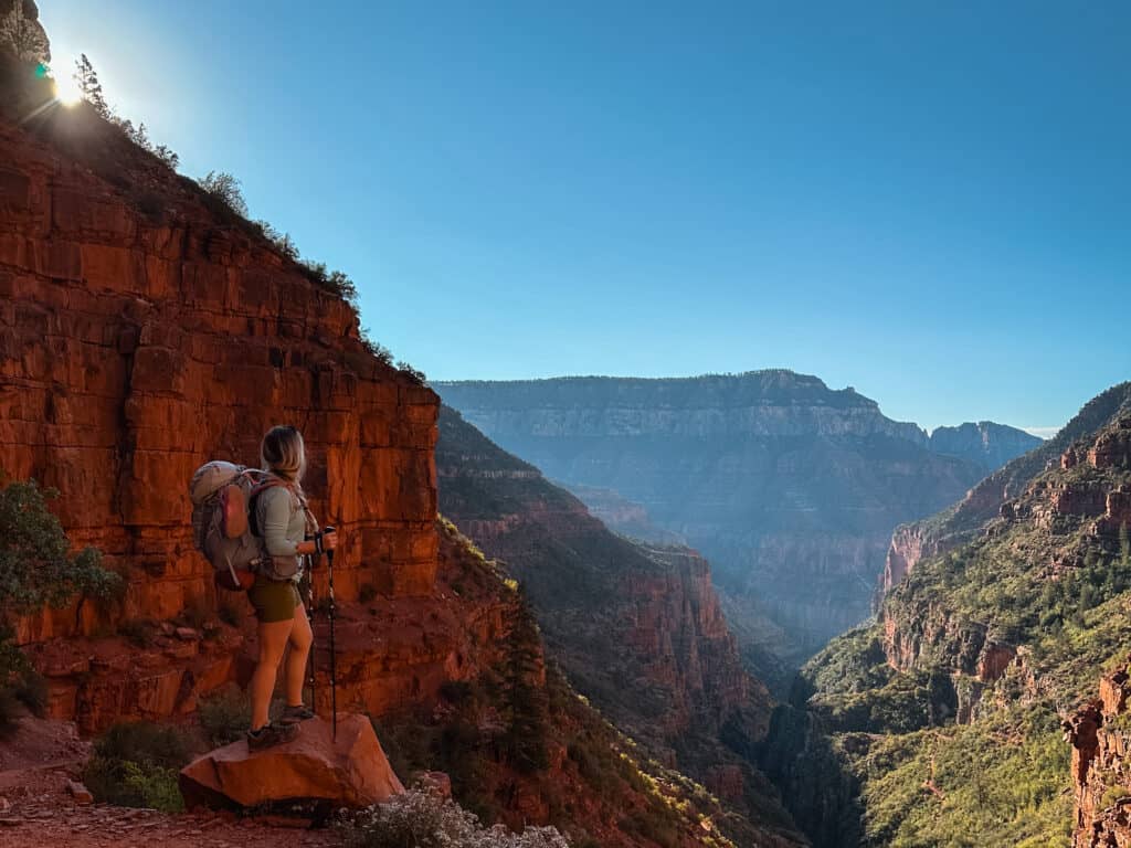
The beginning of North Kaibab Trail is absolutely stunning. I highly suggest getting an early start since you’ll have a long day ahead of you, and this could mean you’ll be hiking the first portion in the dark. It is what it is, but, if you’re able to witness the first mile and half in the light you’ll be pleasantly surprised with the tall pines and greenery along the way.
In our case it was October and the leaves were beginning to turn colors. I was grateful to have been able to witness fall colors, even if it was for a short while!


North Kaibab Trail wastes no time and begins descending right away. Overall the trail is wide enough for two, covered with dirt, and somewhat rocky in areas. Be careful and watch your step so you don’t roll an ankle while gazing up at the trees like we did.
You’ll get some canyon views through random openings in the tree canopies but nothing like you get on South Kaibab if you’ve hiked that one before. North Kaibab is a different type of beauty. There is one killer view, however, once you reach an overlook called Coconino Overlook. You won’t miss it!

After the overlook you hike back into the tree canopies and head to Supai Tunnel.
Supai Tunnel
1.7 miles from North Kaibab Trailhead.
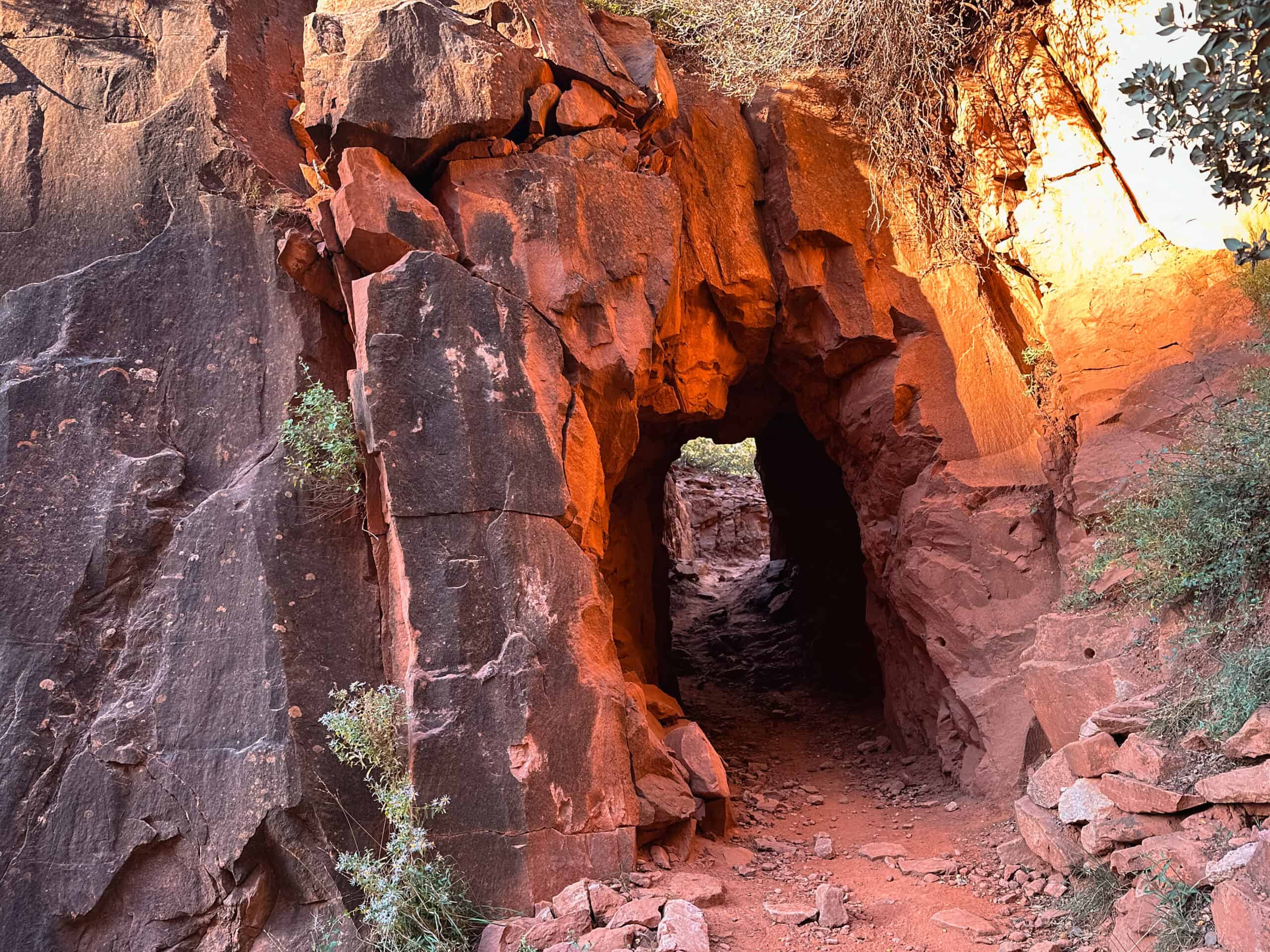
Won’t be long and you’ll hike through Supai Tunnel. This tunnel was created by the National Park crews back in the 1900’s during the construction of the North Kaibab Trail. To form the tunnel they used dynamite, portable drills, and jackhammers to blast and carve through the rock.
After Supai Tunnel the trail becomes much more rocky and exposed. Which only means one thing- great views the rest of the way! Also sun exposure so be sure have sunglasses and a hat.


Due to the heavy packs on our back (because we were backpacking) I was extremely thankful to have hiking poles with me. Honestly they saved my joints and helped my balance countless times during this trip. When descending into the canyon it can be painful on the toes, knees, and ankles. I highly suggest having a pair with you!
Manzanita Rest Area
5.4 miles from North Kaibab Trailhead.
Technically the first rest area is Roaring Springs however it was closed when we passed and has been closed for quite some time. So the first available rest area heading down North Kaibab Trail currently is the Manzanita Rest Area.
They have potable water and restrooms at this location. Not a bad place to stop for a snack either but my group and I decided to push further along and wait for the next stop.

I was so surprised at the amount of flowing water along the North Kaibab Trail, but considering the canyon is called Roaring Springs Canyon I guess it makes sense! I saw one giant waterfall and many smaller waterfalls along the trail. Keep your eyes peeled in the distance for there are some waterfalls you can see but not hear.
Cottonwood Camp Area
6.8 miles from North Kaibab Trailhead.
The trail continues to Cottonwood Camp Area which hosts restrooms, potable water, picnic tables, and some campsites. This is where we stopped to eat breakfast, fill up water, and let our legs rest a bit.
There is a path that brings you down to the Bright Angel Creek so you can dip your feet in the cold water. I love doing this because it is refreshes your feet especially if they are hurting!
From Cottonwood Rest Area the North Kaibab Trail continues descending. From here on out the trail is extremely exposed, sunny, and rocky. But it is beautiful because you hike along part of the creek for a good portion.
Ribbon Falls
8.4 miles from North Kaibab Trailhead.
Less than two miles from Cottonwood and you’ll hike upon a junction to detour to Ribbon Falls. This waterfall is a stunning natural waterfall in the canyon that not many people get to visit. Reaching this waterfall usually requires a long and strenuous hike, but, luckily you’re already doing the hardest part.
Ribbon Falls is only 0.5 miles off the North Kaibab Trail so if you’re wondering if it is worth it- yes!


Visiting will add no more than 1.0 miles to your overall mileage for the day. It is fun though because you have to cross the Bright Angel Creek and find your way along social trails to climb up to the waterfall.
It gets pretty steep at parts but luckily the trail isn’t too long. You’re able to dip your feet in the pool of water below and walk behind the waterfall itself!
If you are interested in adding this detour to your Rim to Rim hike, check out the trail guide below for more details on the Ribbon Falls Trail.
Read the full trail guide: coming soon!
Phantom Canyon & The Box
Continuing along North Kaibab Trail the portion between Ribbon Falls junction and the Box Canyon is the most dreadful of all. It isn’t super rocky or strenuous by any means, but, it is sandy, long, flat, and extremely hot during midday. There is NO shade!
Usually by the time you hit this portion of the trail you’ll be tired and the sun will be high in the sky, baking you as you hike. This portion gives you a good taste of exactly what it feels like to hike in the open desert.
Push through it not only because you have no choice but also because the Phantom Canyon ahead provides a relief!


This is my favorite section of the entire North Kaibab Trail. The canyon walls tower above you, providing only enough room for the creek to flow through and the trail to run alongside it. You’re provided shade, the sound of rushing water, and some of the best views I’ve seen of the Grand Canyon.


Phantom Canyon & The Box somewhat blend together and to be honest I couldn’t tell one apart from the other while hiking. It is just one big long canyon that goes on for a few miles until it gives way and you find yourself hiking upon Phantom Ranch.
Phantom Ranch
13.6 miles from North Kaibab Trailhead.

Once you pass through The Box you’ll find yourself hiking upon Phantom Ranch, the little town located at the bottom of the Grand Canyon. Here sits the private cabin lodging that is only available by reserving years in advance. It is difficult to get reservations here but if you can it is worth it!
What is available to everyone, though, is the Canteen. I highly suggest stopping by to grab a snack, drink, or sticker while passing through. They have great ice cold lemonade as well as alcoholic drinks for purchase!
Bright Angel Campground
14 miles from North Kaibab Trailhead.
Just past Phantom Ranch is the Bright Angel Campground. In my opinion it is the most beautiful campground in the Grand Canyon because Bright Angel Creek runs through the area and you’re able to pitch your tent along side it.

If you have a backpacking permit you’re able to choose whichever campsite you’d like. It is more of a first come first serve deal so if you’re rolling up later in the evening it may be slim picking. The park service only allows enough permits for the campsites allotted, though, so you should never be ‘out’ of a spot.
There are two potable water refill stations and restrooms at the campground. If you’re just passing through I’d definitely fill up your water here before you connect to the Bright Angel Trail because it will be several miles until the next water station!
Bright Angel Trail
Whether you’re climbing out of the canyon the same day or the very next, you’ll be connecting to the Bright Angel Trail.
You have to hike through the campground, past the restrooms, and hang a right to follow the trail that leads you to the Silver Bridge. This is a suspension bridge that allows you to cross the Colorado River! It is the most picturesque bridge in the canyon so definitely stop to take your picture halfway across like a real tourist. I have no shame.

Once across the bridge you turn right to hop on the Bright Angel Trail! This is where your journey climbing out of the canyon begins. But first- a bit of fun before the real work starts.
For a full guide and more pictures of Bright Angel Trail visit- Hiking The FULL Bright Angel Trail To Phantom Ranch
Pipe Creek Beach
8 miles from Bright Angel Trailhead.

If you want to dip your feet into the Colorado River then a stop at Pipe Creek Beach, also known as River Rest House, is a must! 1.5 miles from Bright Angel Campground you’ll hike upon restrooms on the right side of the trail. Here, you can take a spur trail down to the sandy beach and dip your feet into the chilled water.
Swimming in the Colorado River can be very dangerous due to the currents. It is not suggested to swim here, but dipping your feet in or going up to your knees should be safe enough. Just pay attention to the currents!
After you’ve had your fun in the water then hike back up the spur trail and hop back on Bright Angel.
Havasupai Gardens
4.8 miles from Bright Angel Trailhead.
The section from Pipe Creek Beach to Havasupai Gardens is actually quite beautiful and I enjoy hiking it every time. The trail has several shaded sections, is lush with greenery, and if you’re lucky the water will be flowing so you’ll have opportunities to cool off.
During our Rim to Rim trip a large section of the trail turned into a stream. We were hiking in ankle deep water! It was welcomed because the temperatures were 90 degrees and we already had on our water shoes- aka Crocs. My husband deserves a Croc sponsorship because this is his third time hiking the canyon in them- kudos!
Moral of the story- don’t forget some type of water shoes. If you’re day hiking it may not make sense, but if you’re making it a multiday trek I highly suggest it.

Havasupai Gardens has a campground, restrooms, and water fill station. This is a good spot to take a rest, eat a snack, and prepare yourself for the grueling hike out of the canyon.
From here on out the trail only gets steeper and more difficult.
3 Mile Resthouse
3 miles from Bright Angel Trailhead.

Once you’ve reached 3 mile resthouse that is when you know you’re getting close to completing Rim to Rim! But 3 miles up steep switchbacks sure feels a lot longer than it is.
The portion of Bright Angel Trail from 3 mile to 1.5 mile resthouse is the most difficult to me. It is extremely steep, has many wooden steps, and seems like it goes on forever. Don’t try to count the switchbacks, don’t look at your map, just focus on your breathing and push through if you can!
1.5 Mile Resthouse
1.5 miles from Bright Angel Trailhead.

1.5 mile resthouse sure sneaks up on you but when it does you’ll be thankful. You’re so close to the South Rim at this point!
This portion of the trail is still steep with never ending switchbacks but the anticipation of reaching the rim will carry you through.
The feeling of completing a Rim to Rim hike is unexplainable and it is something to be celebrated! Once you hit that pavement again it sure feels weird, and as much as your body is aching, there is still a yearning to be back inside the canyon.
Recap On Hiking Rim To Rim In Grand Canyon
The Rim to Rim hike in the Grand Canyon is one of the most difficult hikes I’ve done thus far in my lifetime. It was thrilling, beautiful, and painful all at the same time. While I was hiking it I kept telling myself “never again…for at least two more years.” Now as I write this trail guide just weeks later I am wanting to plan my next R2R- South Kaibab to North Kaibab!
My favorite part of this trip was hiking through the Phantom Canyon and sleeping at Phantom Ranch. That night we had walked over to the Canteen to order drinks and have them with our dinner at our campsite. We had worked so hard to get there that day and I didn’t want it to end. If I could spend multiple days down at the bottom I would have!
There is a lot of preparation that goes into a hike like this. Not only physically but for gear and logistics as well. I hope this guide has been able to help you plan this hike of a lifetime, and if you have any questions still lingering please leave a comment below!
You may also like:
- Best Guide To Hiking The Full South Kaibab Trail In One Day
- Grand Canyon Bike Rentals Are The Best Way To See South Rim
- Desert View Drive- 5 Scenic Stops On Grand Canyon South Rim
- 9 Short And Easy Hikes In Flagstaff, AZ
- BEST things to do when visiting Winslow, Arizona
So cool, would love to visit this with my partner. We are planning it. Your pictures are amazing!
Hi Fransic! I hope you and your partner are able to make the trip and all goes wonderful 🙂 Thanks for reading!