

One of the most serene hiking trails in all of Arizona is the Thompson Trail 629 in Apache Sitegreaves National Forest near Greer, Arizona. It sits at a higher elevation- around 8,600 feet- so it is lush with grassy meadows, tall Douglas Fir, fresh rivers, and vibrant wildflowers.
It is the perfect trail choice if you aim to escape the city for a slower, more relaxing time in the mountains. This area is so far out that you’ll lose connection to the outside world and be able to breath in some fresh air.
Whether you’re on a solo adventure or including the entire family, Thompson Trail is one everyone can enjoy- especially the furry ones.
In this guide we’ll go over the best seasons for hiking Thompson Trail, how to get there, and tips for a safe hike.
Hey there! Just so you know the below links contain affiliate links, which means I may receive commissions if you choose to purchase through my links (at no extra cost to you). You can visit my disclosure for more info.
Thompson Trail 629 Stats
- Hiking Distance | 3-5 miles RT
- Difficulty | Easy
- Elevation Gain | 191 feet
- Total Time | 2-3 hours
- Permits/Fees | None
- Trailhead | Thompson Trailhead 629
- Road Conditions | 2WD, well graded dirt road.
- Dog Friendly | Yes
Below is a map of the Thompson Trail 629 route.

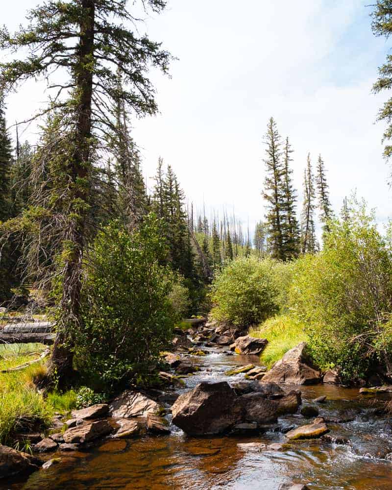
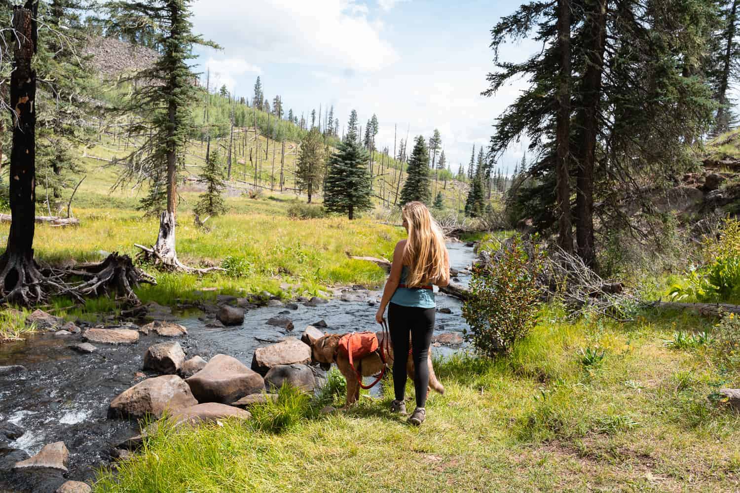
The major allure of Thompson Trail 629 is the fact it follows along the West Fork of the Black River for the entirety of the trail. It creates a tranquil experience because you hear the water rushing downstream as you follow along with the tall trees swaying in the wind high above.
This hike is great for slow movers or families because it isn’t strenuous and you can hike in as far as you’d like then turn around when you’re done. Hiking even 1 mile in is worth it, but you also have the option to connect to other trails and explore deeper into the wilderness.
This guide covers the first 1.25 miles, making this a 3.5 mile round trip hike. The map above shows how deep that distance takes you, which is plenty far enough to experience all the beauty here.
Best Time To Hike Thompson Trail 629
Due to the high elevation receiving snowfall the roads may be closed during the winter and inaccessible. Therefore, starting in late April-May the roads will become clear of snow as it melts and leave you with muddy roads. You certainly can visit during this time but expect mud and some snow left on the trail. The area won’t be so green either.
In my opinion anytime from mid June-August is the best time to hike Thompson Trail if you want to experience the lush paradise and possibly see some wildflowers. September-October the temperatures drop and fall colors pop, so if you want to see some color those months would be great for a visit!
The parking lot holds only a handful of cars so if you expect it to be busy (like a holiday weekend or leaf peeping season) I’d plan on arriving early so you can begin beat the crowds.
Getting To Thompson Trail 629
Remember when I mentioned this trail is ‘out there’? Well, the Thompson Trail sits on the eastern side of Arizona up in the White Mountains and Apache Sitegreaves National Forest. The closest towns for gas and supplies are Pinetop-Lakeside and Greer.
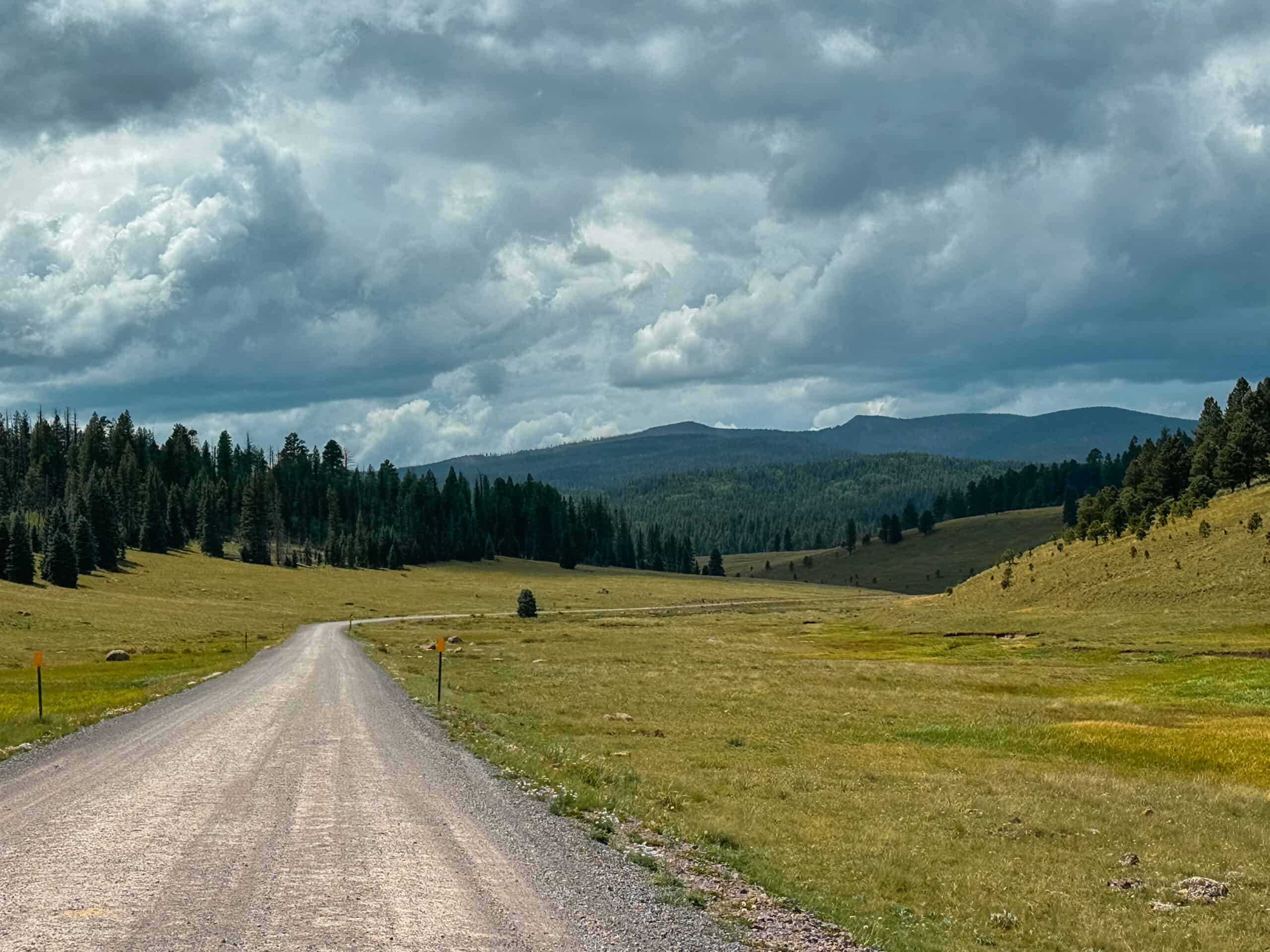
It is about a 4 hour and 15 minute drive from Phoenix and a 3 hour and 30 minute drive from Flagstaff. From both cities you’ll travel through Pinetop-Lakeside and take highway 260 to 273 (turn right). This beautiful highway leads you to turn right on a well graded dirt Forest Service Road. You’ll wind up and through open fields and tall trees until you come upon an unmarked small dirt lot on the right side of the road.
The parking lot is easy to miss but if you type in Thompson Trail 629 to Google Maps it will lead you to where you need to go.
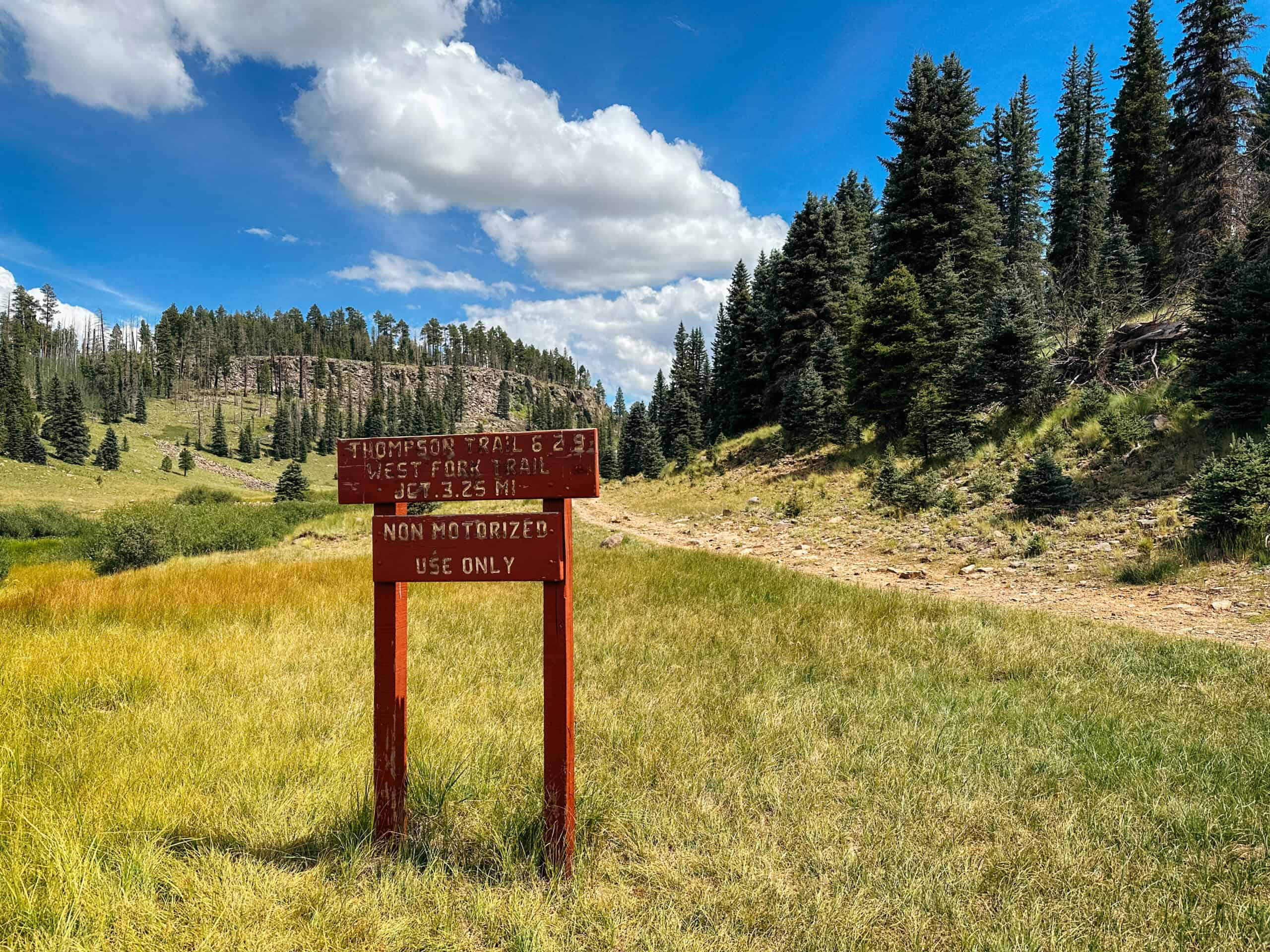
From the parking lot the trailhead is further down the road on the left hand side. There is a wooden sign that marks the trail so you can’t miss it!
Leaving No Trace
In order to continue to have access to places like Thompson Trail and preserve it for future generations, we must take care of them. If we don’t tread lighting we surely will begin to see access revoked in attempt to end the littering and vandalism that takes place.
Please, join me and help keep these beautiful destinations open by learning and practicing the Leave No Trace Principles.
- Plan ahead and prepare.
- Travel and camp on durable surfaces.
- Dispose of waste properly.
- Leave what you find.
- Minimize campfire impacts.
- Respect wildlife.
- Be considerate of other visitors.
These seven principles have been created in hopes to minimize the impact our outdoor spaces endure. Thank you for being a good outdoor steward and following them!
Hiking Thompson Trail 629
The beauty begins right as you start the Thompson Trail! One of my favorite views (pictured below) was actually taken from the dirt road at the beginning of the trailhead. The Black River runs below the road and out the other side, along the side of the trail. You’ll be hiking downstream going with the flow of the river.
The actual Thompson Trail is an unused road, likely an old logging road. At first you follow the road until you hike upon a wooden post and gate. Don’t go past the gate if you want to hike along the water! Instead, on the left side there will be a somewhat rocky trail that leads you down to the river. There is a white sign posted so you can’t miss it.

Take this small trail on the left for the remainder of your hike, unless of course you’d prefer to stay on higher ground and just follow the actual road. If you follow the road it will still be a beautiful hike but you won’t access the river for quite a ways.
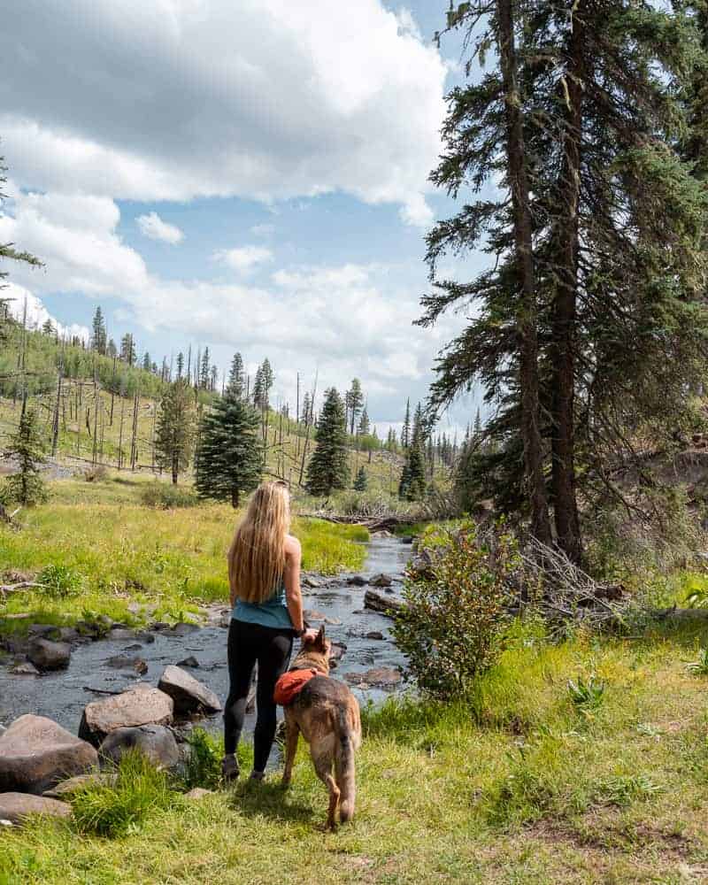
As the trail winds along the river you’ll have a few water access points. My German Shepherd, Monty, loved being able to play in the water off and on the entire time. It isn’t deep at all and was pretty still when we visited.

For the most part the trail is flat and there aren’t any super difficult parts except one that has you climb a steep little hump and back down the other side. It was nothing technical but if you have mobility issues you may need to take it slow or have some assistance.
Eventually the trail narrows enough for single file hiking as it winds through open meadows. The grass is pretty tall and if you’re lucky the wildflowers will be blooming. Please try to stay on the trail as much as possible to protect the vegetation and don’t pick the flowers!

I hiked 1.25 miles in and all of the views looked like what you see in the photos. I turned around at the point when the trail became even narrower and the forest closed in on it. Things became pretty dense and I thought it was a good time to turn around.
If you want to lengthen your hike you can keep following the trail to connect to West Fork 628. You can create a nice little loop and then hop back on the Thompson Trail to return to your car.
Either way, feel free to turn around whenever you feel like it and retrace your steps back to the trailhead.
Where To Camp Near Thompson Trail
Apache Sitegreaves National Forest has many campgrounds nearby and even a few lakes. They also allow dispersed camping!
If you’re looking to stay nearby check out the campgrounds below. Each can be visited on recreation.gov to check for reservations or first come first serve sites.
- Cutthroat
- Grayling
- Rainbow
- Apache Trout
If you’re looking for dispersed campsites you’re in luck! When I was driving through dispersed sites seemed plentiful.
There are several on the way towards the trailhead and even more past it. I am positive if you just drive around you will find one, but I’ll share a few GPS coordinates to spots with you:
- 33.88150, -109.48352
- 33.88205, -109.48275
- 33.90763, -109.45570
- 33.91460, -109.45105 (good for RV’s)
My Time Hiking Thompson Trail 629
Thompson Trail may be a far drive from Phoenix but I felt like it was worth the trip for me. Especially if you make it an overnighter or weekend trip and camp in the forest nearby! I know Monty enjoyed the cooler temperatures and being able to play in the water.
The day I hiked it was very windy and trees were actually falling down alongside and across the trail! I even witnessed a tree fall over into the river. Everything was fine, but do be careful with high winds in this area because there are plenty of dead trees to be knocked down.
I was lucky and it wasn’t a busy day when I visited. Monty and I were the few out on the trail that day which made it even more peaceful. I’d love to return and visit during the fall to see the changing leaves and feel the cool, crisp air, so I have a feeling another visit is in my future.
You may also like:
- Hike Red Mountain Trail To Volcanic Hoodoos In Flagstaff
- Hike Doe Mountain Trail For Best Sunrise In Sedona
- 9 Short And Easy Hikes In Flagstaff, AZ
- 5 Of The Best Sedona Caves And How To Find Them
- 10 Amazing Superstition Mountains Hikes for your Bucket List
Hi Kara
This is Tom from San Diego. For some reason I don’t receive your e-mails anymore about your hikes. Hope all is well!
Great post! Are you aware if backpacking/camping along this trail is allowed? I see you posted local campgrounds and dispersed camping sites, but is camping along the trail itself allowed? I have not seen any definitive answers one way or another in my searches.
Hi Chris! So while I was hiking I did not see any good backpacking spots, but I also didn’t complete the entire trail. When I see sites I typically mark them on my GPS. As far is it being allowed or not…the Apache-Sitegreaves National Forest doesn’t seem to mention much at all about backpacking within their limits. They just state that dispersed camping is allowed anywhere, thus I’d think backpacking is also. I don’t see why it wouldn’t be allowed as long as you set up in a place that has already been impacted and is 200 feet from the trail and water sources (according to the fs.usda.gov website). Thompson Trail connects to others and I’m sure you can find something back there if you’re willing to put in more milage than just the Thompson Trail itself!
Upon further research there may be some good spots at the fork of Thompson Trial and West Fork Trail! Read this forum: https://hikearizona.com/dex2/viewtopic.php?t=10935