
When you think of Arizona landscapes, this is definitely not what comes to mind. That is what makes the Inner Basin Trail so unique- it is a pleasant surprise hidden in the San Francisco Peaks of Flagstaff.
The San Francisco Peaks are the remains of a stratovolcano and cover 1,800 sqaure miles within the Kaibab and Coconino National Forests. The Inner Basin, most commonly reached by the Inner Basin Trail, sits on the Eastern slopes of the peaks.
The trail begins from Lockett Meadow Campground making it a popular hike, and for good reason. The landscape changes drastically from aspen groves to meadows and mountain views. You won’t believe your eyes if you visit during the fall- the Aspens are simply magical!
In this post I’ve included all of the trail details and “need to know” tips about the area. Let’s begin!
Inner Basin Trail Stats
Distance: 5.4 miles RT
Elevation Gain: 1,202 ft.
Type: Out and Back
Difficulty: Easy
Location: Flagstaff, AZ
Trailhead: Inner Basin Trail at Lockett Meadow Campground
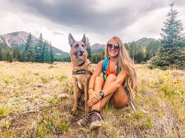
Dog Friendly: Yes
Fees: None for day use.
How To Get To The Inner Basin Trailhead
You can map your directions right here, or visit the map at the end of the post!
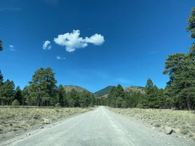
The fun begins once you turn off US Highway 89 onto Forest Road 552. The drive from here continues on a well maintained dirt road which offers dispersed camping spots. You can learn more about dispersed camping in Coconino National Forest on us.fsda.gov.
Eventually you’ll run into an intersection where you’ll turn right, following signs for Lockett Meadow. The next right turn will be shortly after, which is marked with a sign- you can’t miss it!
From here the road turns into one lane which will either excite you or make you turn back.
CAUTION: The one lane road to Lockett Meadow should not be traveled by large trailers, RV’s, Buses, etc. It is very steep, windy, and dangerous for all traffic.
The remainder of the drive climbs and winds up the mountain. You’ll want to continue with caution because there are no guard rails and not much room to pull over for oncoming traffic. But don’t get me wrong…this road is fun and beautiful to drive!
Once you reach the clearing, known as Lockett Meadow, turn right onto the first road and follow it to the back of the campground where there are signs for “day use parking”. The Inner Basin trailhead is at the very back of the parking area.
LOCAL TIP: Parking for day use is FREE. You only have to pay if you are camping over night.

When To Hike The Inner Basin Trail
Monty and I have hiked the Inner Basin Trail during the months of June, July, and October. I’d have to say October is by far my favorite time to hike here because you get to witness the leaves changing colors and breathe the crisp, fresh air.
Late spring or summer are both great times to visit but be careful for summer storms passing through during the mid-late afternoons. Even if there is 10% chance of rain the storms will come out of nowhere and still hit you. Weather conditions at this elevation are unpredictable and can change drastically- so arrive prepared!
The road is closed during winter and at other times when weather, fires, or logging permits it.
PRO TIP: Check the recent reviews on AllTrails to help determine if the gate to Lockett Meadow is open or closed. The Forest Service website is not always correct.
You’ll also want to arrive very early on the weekends, even weekdays now, to snag a parking spot or camping site if you wish to camp. This area has gained popularity and fills up fast.

Hiking The Inner Basin Trail
The Inner Basin trail begins by leading you through a tall pine forest. This part of the trail is mostly flat, leaving the majority of elevation gain for when you reach the Aspen Grove.
Shortly after the pine forest you’ll be transported into an unexpected Aspen Grove which usually takes first-timers by surprise. The skinny white trunks and bright green grass are what make this hike worth the effort- and it takes little effort to reach the Aspens!


During autumn the leaves turn a vibrant yellow / orange and cover the forest floor. Don’t be surprised as you’re hiking through if you end up passing groups of people dressed up taking pictures.
This area is extremely popular this time of year for family photos, etc. But once you hike past this part you’re sure to lose the crowds since most don’t go past the grove.
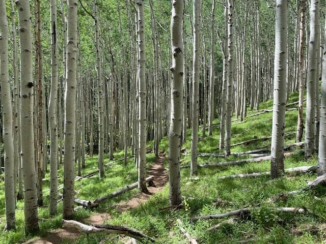
The trail continues in a series of switchbacks, leading you up to the inner basin. Along the way you can look down into the Aspens and you might be lucky to see the beams of light shining through. This area is simply magical.
Unfortunately, this magical place doesn’t last forever, so be sure to take it all in before you hike to the dirt road called Waterline Road. This is where you’ll turn right and hike along the service road the rest of the way to the Inner Basin.


Eventually you will hike upon a few wooden structures and face a fork in the road. Follow the sign to Inner Basin and you can’t go wrong.
From here it remains a bit steep all the way until the road narrows, leading you into a meadow. This is the Inner Basin, providing stunning views of the San Francisco Peaks.
The first time I hiked here I was confused because I was expecting a basin of water, but no, the water is collected underground so the meadow is the reward!
If you were first attracted to this trail because you saw a picture of a pool of water with mountains behind it (San Francisco Peaks), you actually saw the Lockett Meadow Tank which is located in the front of the Lockett Meadow Campground– you don’t even have to hike to it!

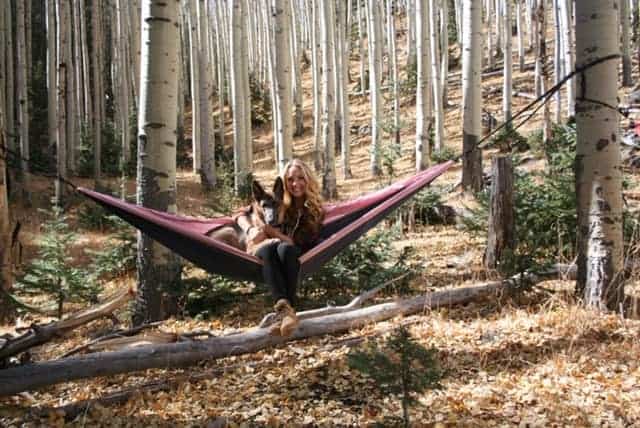
In the Inner Basin Meadow there are two more wooden structures, one that provides a bench and some shade- a perfect photo opp for the area! Monty loved this part the most.
When we visit we usually string our hammock up in the trees surrounding the meadow and hangout for a while to eat our snacks.
Once you’re ready to head back you’ll return the way you came. Luckily this time it is all downhill!
If you think you’ll want to hike more than 5.4 miles and see more than the meadow, you can plan ahead to connect to one of the many trails from this area. See Below!

Nearby Hikes
You could easily spend a whole week in this area hiking different trails. Luckily, Inner Basin Trail connects to other great trails leading you to amazing peaks within the San Francisco Peaks. Here are some popular ones you might want to to connect to:
DIFFICULT HIKES
- Humphrey’s Peak- The HIGHEST peak in Arizona! There are two ways to hike it- the first is 11 miles round trip from the main trailhead which leaves from Arizona Snowbowl.
The second is from Lockett Meadow Campground, taking the Inner Basin Trail. Once you reach the Inner Basin, you continue straight and you’ll see a sign leading you to the left and up the mountain. Once you reach Fremont Saddle, turn right and follow the trail to Humphrey’s Peak.
Hiking to Humphrey’s Peak this way is roughly 18 miles round trip and makes for a very long day. - Fremont Peak- Before you reach Humphrey’s Peak you can summit Fremont Peak. Once you turn right at the Fremont Saddle, this peak is just a little ways down.
- Agazzis Peak- Further down from Fremont Peak is Agazzis Peak, which is more so on the way to Humphrey’s. This is the 2nd tallest peak in Arizona, so you can hit both the 1st and 2nd in one hike if you want!
- Doyle Peak– Arizona’s 4th highest peak can also be reached much of the way way, except once you reach Fremont Saddle, turn left instead and the trail will bring you to the base of Doyle Peak. To summit it, you’ll need to scramble to the top and make your own way for there is no distinct trail.
EASY – MODERATE HIKES
- Bear Jaw / Abineau Loop Trail- Approximately 2 miles in the Inner Basin Trail and you’ll hike upon a sign at a fork that lists Bear Jaw and Abineau Trail. If you turn right, you’ll follow the Waterline Road for a bit and loop into the loop trail, taking you past Aubineau and Rees Peaks.

Final Thoughts On The Inner Basin Trail
The Inner Basin Trail took me by surprise the first time I hiked it because I wasn’t expecting the Aspen grove. I think this trail is a great option for those wanting to get out and experience a different part of Arizona or are new to hiking.
If you’re an avid hiker you may consider taking the Inner Basin Trail to connect to one of the longer trails, leading up into the San Francisco Peaks. To some, this trail and the Inner Basin alone are not worth the long drive.
Regardless, I enjoy visiting this area every year I get to. I enjoy escaping here to hammock in the Aspens and camp at Lockett Meadow Campground!
As always, please be considerate of the environment so we can keep enjoying it and remember to leave no trace.
Nearby in Sedona:
- 4 of the best Sedona Caves and how to find them
- Hiking Cathedral Rock: All you need to know
- Hiking A.B. Young Trail to East Pocket (Edge of the World)
- Hike to Devil’s Bridge in Sedona, Arizona
You may also enjoy:
- Hiking South Kaibab Trail in the Grand Canyon- Complete Guide
- How to Kayak Antelope Canyon from Lake Powell
- 6 Best Bryce Canyon Winter Hikes and things to do
- Hiking with dogs- 10 essentials you should pack
Best of the best of the posts about this hike. Thank you for answering all the things I was thinking.
That is what I’m here for! Thanks for reading, Bob.