
Allow me to introduce you to the Superstition Mountains- an adventurers dream desert mountain range. Hosting magical waterfalls, deep canyons, steep cliff edges, and unique rock formations, this wilderness is the perfect destination for hiking, backpacking, and even rock climbing.
The trail systems throughout the Superstition Wilderness are vast and allow you to create many different routes through the landscape. But in this post I’m going to highlight 15 of the best hikes in the Superstition Mountains as well as important tips for a safe adventure.
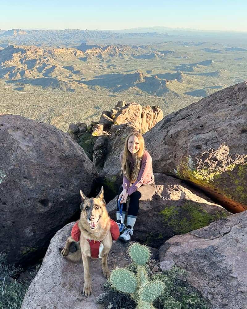
I’ve personally hiked every single one of these trails not only once, but multiple times. The Superstition Mountains are my favorite area to hike in near Phoenix, and I can’t wait to share my top picks with you.
Hi there! This post contains affiliate links, which means purchasing through these links I earn a small commission at no extra cost to you. Thank you for your support! You can view my disclosure for more info.
Where Are The Superstition Mountains?
Commonly referred to as ‘the Superstitions’ or ‘the Supes’, this mountain range is located on the far East side of the Phoenix valley near the cities of Apache Junction and Gold Canyon. From downtown Phoenix it is a 40-60 minute drive depending on what area of the range you’re traveling to. Sounds like a drive, but I promise it is worth it.
A large portion of Arizona’s history lives within this mysterious mountain range. From old mines, tales of lost gold, petroglyphs, and ancient ruins, you just may stumble upon something fascinating.
Best Time To Hike The Superstition Mountains
From my experience, the Superstition Mountains are a desert mountain range which means the trails are dirt, rocky, and many prickly types of vegetation are scattered about. It also means that you will rarely have access to water sources or shade.
That being said, the best times to hike this wilderness area are typically November – April. These are the cooler months in the Phoenix valley which make hiking these trails more enjoyable.
I don’t suggest hiking during the summer unless it is a short trail that you can begin at 4:30 a.m. and get done before late morning. For reference- if it is 85 degrees or hotter, I would be extremely cautious about embarking on an all day hike.
A lot of the parking for these trails are limited and they fill up fast. Begin your hikes early to beat the crowds, or strategize and arrive for a sunset hike if the trail permits.
ALWAYS CARRY A PAPER MAP!
It is best practice to also carry a paper map of the area you’re hiking in. The map below is the one I use for all Superstition Mountain hiking trails. Get the map here!
Tips For Hiking In The Superstition Mountains
The rugged terrain through this mountain range is not to be underestimated. Going in prepared is key. While hiking in the Superstition Mountains you’ll experience sharp cliff drop offs, extreme changes in weather, tough route finding, rock scrambling, and lack of water sources.
Of course some trails will be easier than others. It all depends on how deep you plan on exploring. Below are the tips I find important for any adventurer to know when entering this majestic wilderness:
- Carry a minimum of 2L of water per person, and for the more difficult day hikes 3L. Water sources depend on the season and are scarce throughout the Superstition Mountains so you’ll have to pack in what you need.
- Pack the 10 Hiking Essentials. This includes packing enough to survive a night out incase anything goes wrong (extra layers, extra food, emergency blanket, etc.).
- Utilize a GPS App like Gaia GPS at the very least because some of these trails are not marked. I highly suggest having a paper map of the area as well. It is very easy to lose the trail or take a wrong turn. Tracking yourself on a GPS will help you know where you are and backtrack if you need to.
- Watch for Rattlesnakes. They especially like to come as it starts to heat up outside.
- Share your itinerary with someone before you leave.
- Please practice the leave no trace principals so we all can continue to enjoy this wilderness!
FRIENDLY REMINDER
While the daytime temperature might be warm, once the sun goes down it can get very chilly and fast. Likewise, it may be chilly in the morning, but it can heat up during the day and be dreadful. Always pack layers!
For more tips check out 16 Expert Desert Hiking Tips you need to know
15 Best Hikes In The Superstition Mountains
Finally, in no certain order, are 15 incredible hikes in the Superstition Mountains you won’t want to miss! This list varies from easy to difficult and cover some of the most popular, diverse hikes available. You can’t choose wrong!
Preparation saves lives. Know where you are going ahead of time and always have a way to keep yourself on trail. One way to do this is with a GPS system or app like Gaia GPS.
You can download my tracks for each of these Superstition Mountain hikes and gain access to my library of all tracked hikes. Once downloaded, you can load it into your own trusty device for ease of mind!
Easy Hikes In Superstition Mountains
1. Hackberry Springs
Distance | 3.0 miles
Difficulty | Moderate
Trailhead | Carney Springs Trailhead
Permit | $15 AZ State Trust Land Permit
Dog Friendly | Yes
Hackberry Springs is a stunning little hike that I will always recommend to visitors and families looking to get outside! It is the perfect trail for beginner hikers also.
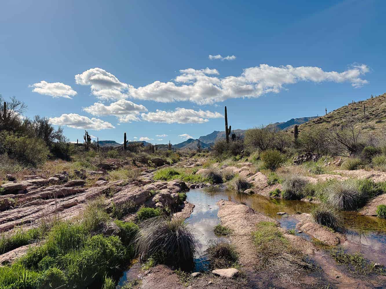
After some seasonal rainfall you can expect the creek to be flowing with fresh water. There is an area where you’ll need to cross the creek but usually there are plenty of rocks to utilize. This part the dogs love!
The sights along Hackberry Springs Trail are simply gorgeous. It is one of the most scenic little trails that you can choose, in my opinion. This is a great place to start!
Read the full guide: Hackberry Springs Loop: Easy Superstition Mountains Hike
2. Hieroglyphic Trail

Distance | 3.1 miles
Difficulty | Easy – Moderate
Trailhead | Hieroglyphic Trailhead
Permit | None
Dog Friendly | Yes
The Hieroglyphic Trail provides a chance to witness a piece of Arizona’s history! While the name has hieroglyphic in it, what you actually will see are petroglyphs carved into the rocks from thousands of years ago. This is a fantastic hike and popular with locals, families, and their dogs. I’ll always suggest this one to Arizona visitors!
About 1.55 miles into the trail the petroglyphs become prevalent on the rocks scattered along the trail. If there was a recent monsoon you’ll be spoiled with a mini waterfall and some pools of water here too.
While the trail may be short I promise it doesn’t sacrifice on views. Sunrise or sunset provide the best lighting for the surrounding landscape, but daytime also provides good lighting for the petroglyphs and playing in the seasonal water.
Read the full trail guide: Hiking The Hieroglyphic Trail In The Superstition Mountains
3. Treasure Loop

Distance | 2.4 miles
Difficulty | Easy
Trailhead | Treasure Loop Trailhead
Fees | $7 Entry Fee
Dogs Allowed | Yes
If you’re looking for a great beginner hike in the Superstition Mountains, Treasure Loop is a the perfect choice. This trail loops around the foothills of the Superstitions without getting into anything crazy, but still provides you with some beautiful desert views.
The trail is pretty rocky so I suggest wearing supportive hiking boots and using trekking poles if you need help with balance.
Treasure Loop begins within Lost Dutchman State Park which charges a $7 entry fee. If you’re looking for a base camp to stay at, reserve your camping spot ahead of time here. Then you can explore the trails right from your campsite.
4. Broadway Cave

Distance | 4 miles RT
Difficulty | Easy – Moderate
Trailhead | Broadway Trailhead
Permit | None
Dogs Allowed | Yes
Broadway Cave features a massive entrance that opens up to the valley beyond. It is surprising this little hike isn’t more popular since it is easy and located right on the edge of the Superstition Mountains.
The majority of the hike is flat up until you reach the base of the cave. You’ll climb all of the elevation at once to reach the entrance but it isn’t anything to strenuous and no scrambling is involved.
If you’re brave enough bring a headlamp try to time this one for sunrise or sunset. The darkness adds to the eeriness of the cave! I couldn’t believe how deep it goes back and was surprised to find it is home for several bats.
Read the full trail guide: How to find Broadway Cave in the Superstition Mountains, AZ
Moderate Hikes In Superstition Mountains
5. Wave Cave
Distance | 3.0 miles
Difficulty | Moderate
Trailhead | Carney Springs Trailhead
Permit | $15 AZ State Trust Land Permit
Dog Friendly | Yes
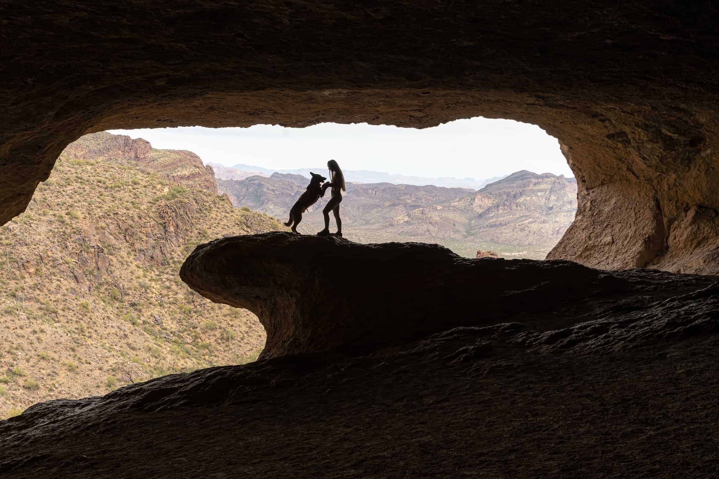
One of the most iconic hikes in the Superstition Mountains is the Wave Cave. This cave is well known for its rock formation that resembles a wave. The Instagram photo op is to “surf the wave” while someone stands in the back of the cave to snap your photo. You can create a great silhouette photo here!
Early bird gets the worm for this trail is packed on weekends. The parking lot is small so I suggest beginning Wave Cave for sunrise. You won’t regret the early wakeup call because you’ll have the perfect view of the sun rising while you sit on the wave.
Overall this hike is moderate and perfect for beginner hikers, families, Arizona visitors, and even dogs!
Read the full trail guide: Local Guide To Wave Cave- The Superstitions Hidden Gem
6. Peralta Trail To Fremont Saddle

Distance | 4.7 miles RT
Difficulty | Moderate
Trailhead | Peralta Trailhead
Permit | $15 AZ State Trust Land Permit
Dogs Allowed | Yes
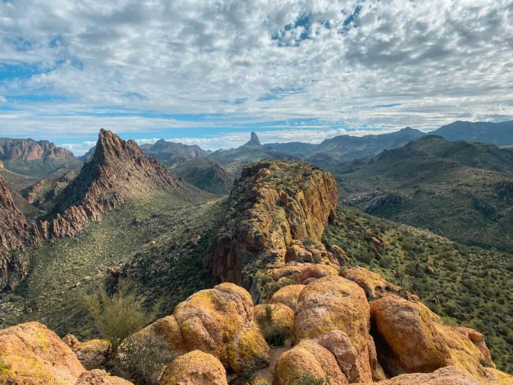
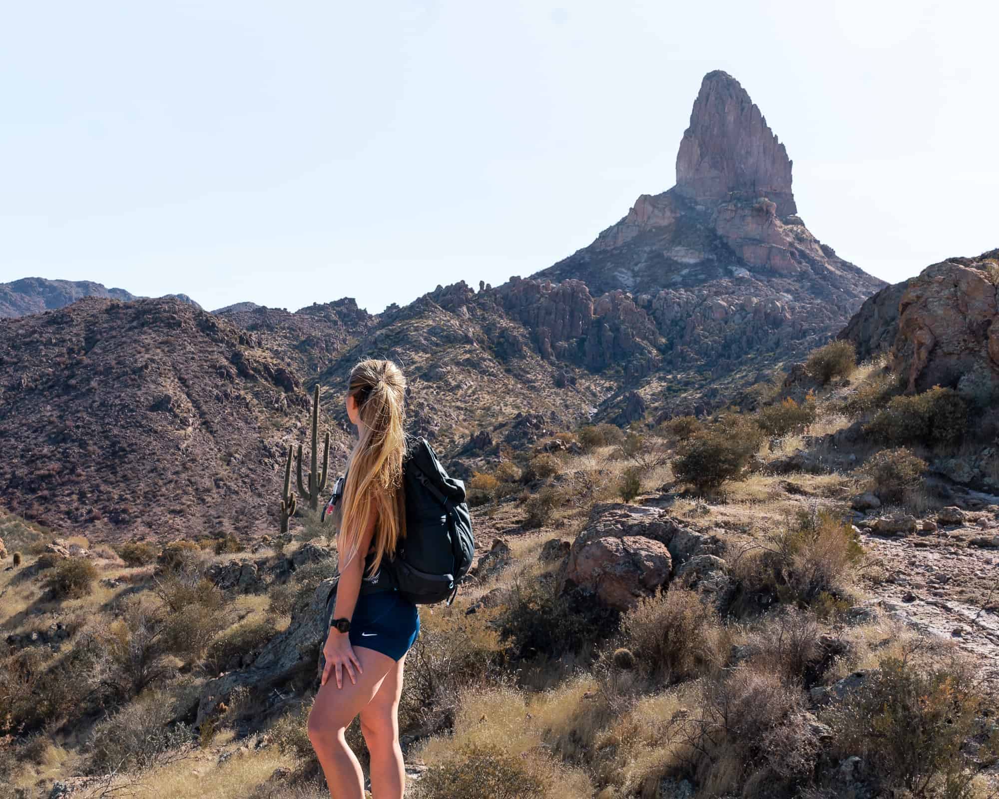
For a very scenic hike look no further than Peralta Trail to Fremont Saddle. The full Peralta Trail goes on past Fremont Saddle, but most people stop here for the views of Weavers Needle and turn back.
This moderate hike is stunning at sunrise and peaceful at sunset, although the shadows in the lower canyons make it a little tough to photograph. From Fremont Saddle you can connect to different trails and extend your hike if you wish.
If you want to begin hiking into the Superstition Mountains this trail is a great introductory one because it gives you a great view into just how vast the range is.
Read the full trail guide: Peralta Trail to Fremont Saddle: Arizona Hiking Guide
7. Weavers Needle Loop
Distance | 12.5 miles RT
Difficulty | Moderate
Trailhead | Peralta Trailhead
Permit | $15 AZ State Trust Land Permit
Dogs Friendly | Yes
From Fremont Saddle (the hike listed above) you can continue along Peralta Trail to connect other trails and create an entire loop around Weavers Needle which I like to call Weavers Needle Loop.
If you haven’t become familiar with this prominent rock formation you will after this hike. This route is an excellent moderate, all day hike around the rock formation and a great way to ease yourself deeper into the Superstition Mountains. While it is long in length the elevation gain isn’t too much to handle nor is it strenuous.
There also are a ton of great backpacking spots at the bottom of the canyon if that is your thing. I’d love to return and sleep under the stars here!
Read the full trail guide: Weavers Needle Loop Trail in the Superstition Mountains
8. Black Top Mesa

Distance | 11.5 miles
Difficulty | Moderate
Trailhead | First Water Trailhead
Permits | None
Dog Friendly | Yes
Are you familiar with Weavers Needle yet? It is the most iconic landmark in the Supes and there are several great hikes where you’ll get to view it from a different angle. Black Top Mesa is another hike that features the needle, but also something else that is unique.
The Superstition Mountains were once a series of volcanoes that collapsed into themselves, and after years of erosion and natural elements they’ve become what we see today. Black Top Mesa received its name because of the black basalt lava rocks that reveal themselves at the top.
Overall the hike is moderate due to the length of it. For the majority of the hike you’re traveling on pretty level ground, and then once you make it to the base of the mountain it is a steep climb up a small social trail.
Read the full trail guide: Hiking Black Top Mesa In The Superstitions Is Worth It
9. Massacre Falls

Distance | 5.6 miles RT
Difficulty | Moderate
Trailhead | Massacre Grounds Trailhead
Permit | None
Dog Friendly | Yes
If you time it right you’ll get to witness a magical waterfall within the Superstition Mountains. The kicker- it only appears after rainfall which as we all know is very unpredictable and sparse in the desert. But when it does snow or rain you’ll want to be ready to rush on over to Massacre Falls and catch the waterfall in action.
A small pool of water is created at the base of the falls and is extremely cold but refreshing! You’re able to explore the area and climb up to the ledge that sits in the rock wall behind the flowing water.
Even if you’re not able to time it right for the waterfall, this trail is beautiful during spring bloom!
Read the full trail guide: Massacre Falls | A magical waterfall in Phoenix’s Superstition Mountains
10. Canyon Of The Waterfalls

Hiking Distance | 4.9 miles RT
Difficulty | Moderate
Trailhead | Crosscut Trailhead
Permit | None
Dog Friendly | Yes
When it rains the desert comes alive and that couldn’t be more true for Canyon Of The Waterfalls. Rightly named, it is best visited after a very heavy rainstorm for the entire canyon will be flowing with water.
Unlike Massacre Falls, Canyon Of The Waterfalls will make you work quite a bit to reach it. For the most part the trail is easy to follow, however, it is an incline almost the entire way.
Regardless of flowing water or not, if you’re looking for a different hike to do and some beautiful sights to see, this one would be a good option and probably less populated!
Read the full guide: Hike Canyon Of The Waterfalls After It Rains In Phoenix!
Difficult Hikes In Superstition Mountains
11. Flatiron Summit

Distance | 6.5 miles RT
Difficulty | Difficult
Trailhead | Siphon Draw Trailhead
Fees | $7 Entry Fee
Dogs Allowed | Yes, but only the experienced.
Simply put- Flatiron it is an epic day hike that consists of hiking up a slippery draw, scrambling up large rocks, and summiting one of the most challenging summits in the Superstition Mountains. Flat Iron is one of the “must do” hikes to establish your “clout” in the hiking community. If you’ve conquered this one then you can do just about anything.
Your glutes will burn, you breathing will grow heavy, and you may begin to question why you wanted to do this hike in the first place. But once you finish the climb to the top the views will quickly remind you.
If you’re looking for more of a easy-moderate hike and don’t want to scramble all the way up to Flatiron, you have the option to hike to the Siphon Draw and turning back. The draw is right before the scrambling begins so you won’t have to worry about any of that. If it has rained recently there will be a small waterfall and water trickling down the draw!
DOG SAFETY
Dogs are able to use this trail but be advised that scrambling is required and there may be a couple areas they’ll need a lift up. Only let them attempt it if they are experienced, in good shape, and you fully believe in their climbing abilities.
Read the full trail guide: Ultimate Guide to Hiking Flatiron via Siphon Draw Trail
12. Battleship Mountain

Distance | 12 miles
Difficulty | Difficult
Trailhead | Dutchman’s Trailhead
Permits | None
Dog Friendly | Not advised
If heights don’t bother you and you enjoy the challenge of scrambling and route finding- this one is for you. Battleship Mountain is my favorite hike in the Superstition Mountains because it is an all day adventure with a high reward.
It isn’t for the faint of heart, though. Once you make it to the base of the mountain you’ll have to climb a pretty steep climb up a single boulder. Then, once you’re on top of the spine of the mountain, you’ll continue to boulder climb and scramble to the other end. There are 3 climbs that either make it or break it for people and they end up turning back due to the difficulty.
But, if you do make it all the way to the other end of Battleship Mountain you’ll be rewarded with the most stunning views in all of the Superstition Mountains. As you view down the spine and gasp at where you came from, you’ll be looking at my favorite views in these mountains. You can even spot Weavers Needle way off in the distance!
DOG SAFETY!
Dogs can use this trail until you reach the base of the mountain. From then on, I highly advise to not attempt making them climb up the base of the mountain and down the spine. This part is all the fun though, so I suggest you leave your furry friend at home.
Read the full trail guide: Hike Battleship Mountain via. First Water Trailhead
13. Three Sisters Summit
Hiking Distance | 7.2 miles RT
Difficulty | Difficult & Strenuous
Elevation Gain | 2,312 feet
Three Sisters Summit is one of those hikes you’ll likely only want to do once. It is steep, strenuous, and covers a good amount of milage. It isn’t technical by any means…it just is that steep.
But, the views from the summit are some of the best in the Superstition Mountains and you’ll likely be the only one there too. For these reasons, Three Sisters is worth the climb!
The trail actually begins from the same parking lot as Wave Cave at Carney Springs. You’ll follow along the Carney Springs Trail for a bit, as if you were heading to Wave Cave, but then veer off on another trail to the right. This trail leads you up to Three Sisters, on top of Wave Cave!
Read the full guide: Conquering Three Sisters Summit In The Superstition Mountains
14. Peak 5057 Via. Hieroglyphic Trail

Hiking Distance | 7.3 miles RT
Difficulty | Difficult
Trailhead | Lost Goldmine Trailhead
Permit | None
Dog Friendly | No, please leave them at home.
Superstition Peak 5057 is the tallest peak in the Superstition Mountains! There are several approaches you can take to summit the peak, but one really fun one is via the Hieroglyphic Trail, which we covered above!
You can continue past the popular petroglyph area and follow the trail all the way up the steep Hieroglyphic Canyon until it intersects with the Ridgeline Trail. Turn right on this trail to take it all the way to Peak 5057.
The views at the top of 5057 are some of the absolute best, so naturally this hike has become one of my favorite hikes in the Superstition Mountains.
Read the full guide: How To Hike Superstition Peak 5057 via Hieroglyphic Trail
15. Superstition Ridgeline Trail

Hiking Distance | 10.6 miles one way
Difficulty | Difficult
Trailhead | Siphon Draw & Carney Springs Trailheads
Permit | None
Dog Friendly | No, please leave them at home.
Perhaps I’ve saved the best hike in the Superstition Mountains for last! Whether you agree or not depends on if you like a challenge.
This point to point hike is deemed one of the hardest hikes in the Phoenix Valley, as well as in the mountain range itself. You’ll park at one trailhead, hike to the other, and need to be shuttled back to your parked car.
You’ll climb 3,400 feet in elevation as you hike and scramble along the Superstition Ridgeline. The hard work doesn’t go without reward for the views along this route are absolutely fulfilling. Be sure to read the trail guide below for more important hike information!
Read the full guide: Superstition Ridgeline Trail: Best Hike In Superstition Mountains
More Nearby:
- Tom’s Thumb Trail in Scottsdale, AZ- all you need to know
- Hike Pinnacle Peak Trail in Pinnacle Peak Park, Scottsdale
- Ultimate Picacho Peak Hike Guide via The Hunter Trail
- Visit the Old West Town of Tortilla Flat, Arizona
More in Arizona:
- 5 Of The Best Sedona Caves And How To Find Them
- Hiking with dogs- 10 essentials you should pack
- How To See Grand Falls (Chocolate Falls) Flowing
- How to Hike to Humphrey’s Peak- Arizona’s Tallest Peak
- A Day Trip to the Arizona Meteor Crater National Landmark
Recap: The Best Hikes In The Superstition Mountains
We’ve only begun to scratch the surface when it comes to hikes in the Superstition Mountains. The wilderness is vast and has many different routes you can piece together for both day hikes or a backpacking trip. The options are almost endless!
If you’re new to the desert and this wilderness, I’d suggest starting with a beginner trail or one of the shorter trails such as Wave Cave. This will give you a great introductory into these mountains, and then you can go from there!
As always, please be considerate of the environment so we can keep enjoying it and remember to leave no trace.
Thank You loved The article have been looking for some good trails at the Superstition Mountains going to give some of them a tryWith my hiking Buddies
Wow! These hikes are breathtaking! I love coming across little nuggets of paradises on the web and learn about them. Perhaps, someday I will get to visit them also.
These look like so absolutely stunning hikes. Thank you for sharing.
Hi Lauren! Thanks for reading. The Superstitions hold some of the most beautiful hikes and I am happy to share them.