
Here is your chance to hike and witness a bit of forgotten Arizona history! Tucked away in the Mogollon Rim is Payson’s Railroad Tunnel- an incomplete project from the 1880’s spearheaded by a business man by the name of James W. Eddy.
His vision was to connect Arizona’s north and south railroad networks to transport mining and lumber goods back and forth. There was only one problem…and a major one at that. The Mogollon Rim- a 200 mile long geographical feature that hosts thousand foot drop offs made of limestone, sandstone, sedimentary, and even volcanic rock- stood in his way.
This didn’t hault his ambition for he and his crew began blasting through the rock to create the tunnel anyways. Funds eventually ran out and he wasn’t able to secure investors to keep the project going, so the work stopped and today we’re left with the 70 foot tunnel they left behind.
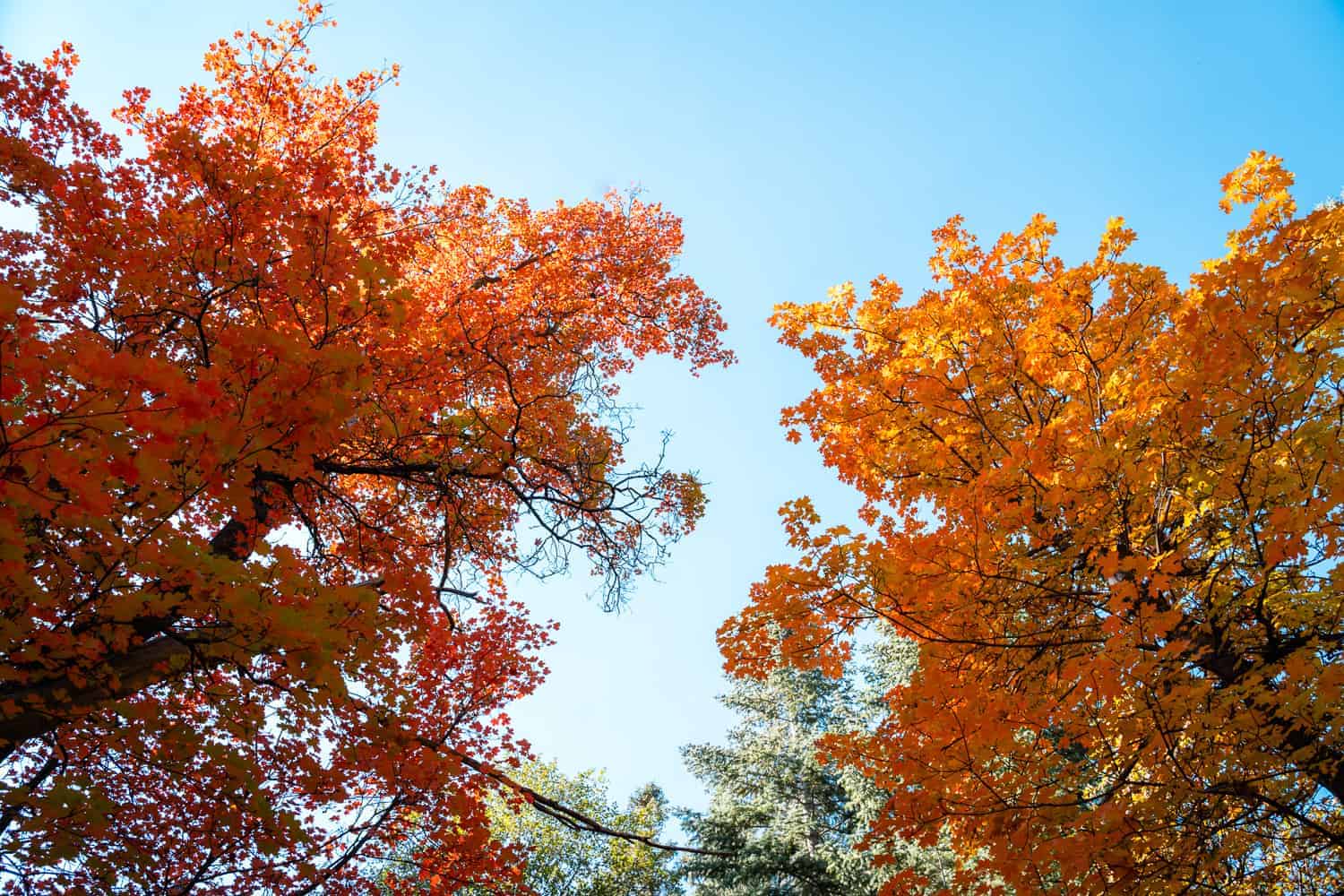
Don’t go anywhere just yet because the Mogollon Rim Railroad Tunnel isn’t the only highlight of this hike! The trail follows along a portion of the East Verde River providing opportunities to appreciate the fresh water. I visited in early November and the fall colors were at their peak so this is definitely a great fall hike!
Now, let’s get to the details of how you can visit too!
Railroad Tunnel Via Arizona Trail Stats
- Hiking Distance | 3.70 miles RT
- Difficulty | Moderate
- Elevation Gain | 874 feet
- Total Time | 3-4 hours
- Permits/Fees | None
- Trailhead | Washington Park Trailhead
- Road Conditions | Well graded dirt, 2WD okay.
- Dog Friendly | Yes
Below is a map of the route to the Railroad Tunnel via Arizona Trail and Washington Park Trailhead.

You technically have 3 different options for reaching the Railroad Tunnel. First and shortest is to hike from the Mogollon Rim Road 300 but it is a much further drive if you aren’t actually traveling along the rim. Second is to hike along an old road called Colonel Devin Trail 290. This is more of a straight shot from Washington Park Trailhead but it is just an old, unused road. Not too scenic if you ask me.
Third option, and the one this guide is geared towards, is hiking to Railroad Tunnel via Arizona Trail, which also leaves from Washington Park Trailhead. But instead it follows along the East Verde River and meanders through beautiful parts of the forest, creating a much more pleasant experience.
Local Tip!
If you’re just looking to see some fall colors and get out in the fresh air this portion of the Arizona Trail is a wonderful option! You don’t have to hike all the way to the Railroad Tunnel. Just hike in as far as you’d like, enjoy the scenery and fresh air, then turn back once the trail intersects with the Colonel Devin Trail 290.
Getting To Washington Park Trailhead
The Washington Park Trailhead is about a 40 minute drive from the heart of Payson. The road eventually becomes a well graded dirt road in good enough condition for 2WD, however pay attention to the weather for heavy rain or snow may make the road impassible.
You can input Washington Park Trailhead into Google Maps and it’ll lead you right to it, or, follow the directions below.
From Payson head North on Highway 87 then turn right on Houston Mesa Road NF 199. This road will wind and climb in elevation, taking you past another local favorite hike- Water Wheel Falls. Continue following the road past Whispering Pines, then keep a look out for NF 32 on the right, and turn there.
Continue on for a couple miles and there should be a sign for Washington Park Trailhead. You’ll turn right, then almost immediately left, and follow that dirt road to the end where the parking lot is. If you find yourself at Washington Park right by Mountain Ridge Cabins then you’ve missed the turns and need to back track.
Best Time To Visit Payson’s Railroad Tunnel
Due to the high elevation I feel that summer and fall are the most beautiful times to hike to Railroad Tunnel. The temperatures can still get hot during summer but if you do this hike in the early morning or later evening you can miss the worst part of the day. I just wouldn’t suggest making the climb to the tunnel during the hottest part of the day during summer because you’ll bake. Keep scrolling and you’ll see why!
The fall colors on the way to the tunnel were beyond stunning! They actually turn more towards the end of October and well into November so if you missed October colors elsewhere this would be a good area to still consider. I visited the first weekend of November so the images in this guide show how late in the season the leaves fall.
The Washington Park Trailhead can get packed at times. When I visited during late morning on a Saturday I took one of the last few spots. Seems like it is best to get an early start here.
Another local favorite: See Spring Trail- A Fall Staple In Payson, Arizona
Hiking To Railroad Tunnel Via Arizona Trail
At the parking lot you’ll see an old gated road which marks the beginning of the Colonel Devil Trail 290. On the opposite end of the lot, almost right where you pull in, is the start of the Arizona Trail portion. This is the trail you want to take!
The AZT (Arizona Trail) splits a large rock and takes you past a 2 large wooden signs. It starts out pretty flat and quickly crosses the East Verde River. There are 2 beautifully built wooden bridges along this route, spanning the the river so it is easy to cross. Both are great spots to meander down to the water for some peaceful views. I know the dogs love being able to wade in the water here!


During early November there were still plenty of leaves on the trees, vibrant in color. The air was cooler and the only sounds that could be heard were those of the forest- rushing water, frog croaks, and bird songs all around.
Along the way there are several spots where social trails dip down to the river. Since I had Monty with me and he loves water I was pulled to explore almost every single one of these. They are short and worth taking because you get to see small little waterfalls you otherwise wouldn’t have!


The forest oasis doesn’t last forever and the Arizona Trail eventually intersects with Colonel Devin Trail 290. Here the trail is wide enough to hike side by side and becomes a bit steep at parts. If you want to visit the Railroad tunnel you’ll follow along the old road for about 0.5 miles until you see a trail on the right, where the AZT veers off again.
Follow the AZT on the right to head to the Railroad Tunnel.
If you don’t want to visit the tunnel, though, it really isn’t worth hopping on the Colonel Devin Trail. I suggest turning around at that point and just stay on the scenic portion of the Arizona Trail you were on.

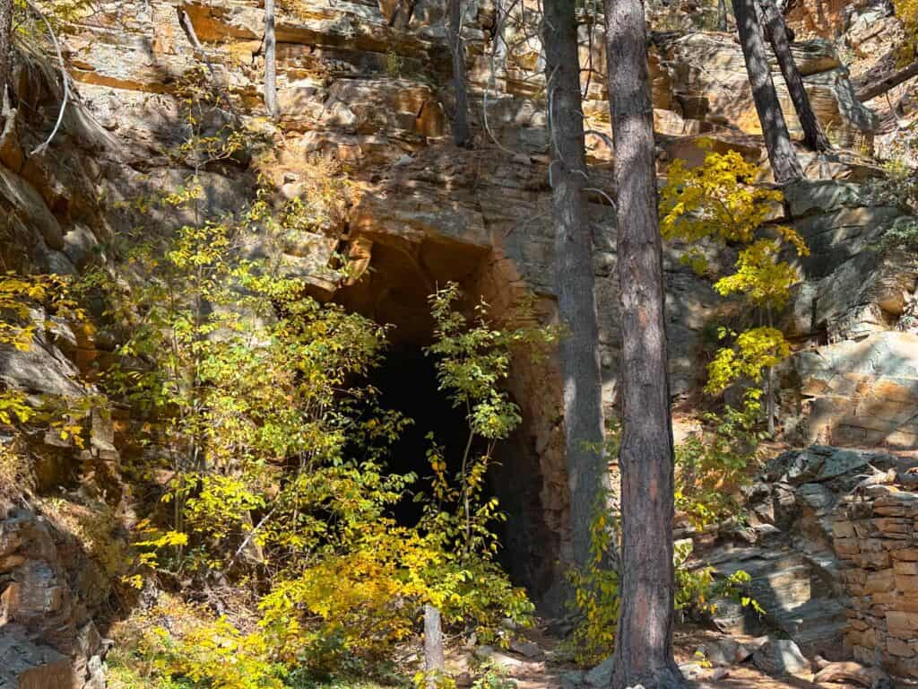
From here on out it is all business to reach the Railroad Tunnel. The lush greenery disappears as the tall pines take over and the trail becomes rocky.
Eventually the AZT will come to a very tight switchback and there will be a sign that points to SS Tunnel. Here you’ll want to follow the sign and turn right (onto what some deem as Railroad Tunnel Trail) to reach the tunnel. If you continue following the AZT to the left you’ll hike all the way to the Rim Road, which you don’t want to do!
The social trail, or Railroad Tunnel Trail, isn’t currently on any official map and most likely not visited often so you’ll have to follow what faint trail you can see.

It gets very steep and there will be a few parts that require slight scrambling. Once you reach a discouraging hill full of light colored scree you’ll know you’re getting close. At this point you’ll probably be wondering where in the heck is the tunnel?
Well, the tunnel is just beyond the log pictured above, at the top of that hill! You just have to make it up the last sketchy, steep climb and you’ll be there.
Be sure to watch your footing especially when coming down. A older gentleman slipped on the loose rock and fell while I was headed up. This climb up to the tunnel is not young kid friendly.

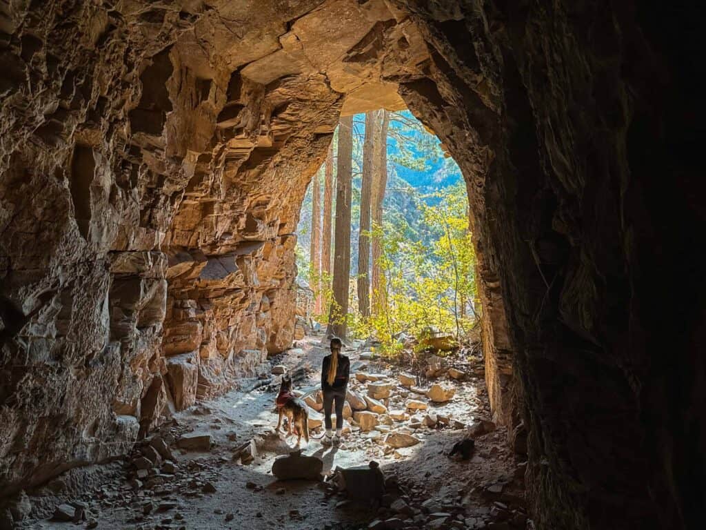
Once over the log you’ll be able to see the tunnel tucked back and almost hidden by the tree branches. There will be an old stone structure right outside from the 1800’s which housed the explosives the men used to create the tunnel.
The mouth to the tunnel is grand but the tunnel itself is only 70 feet deep and narrows as it goes on. Crazy to think of the large feat it would have been to create the entire railway, and this is as far as they got.
Unfortunately there is some graffiti in the tunnel but if you can look past that it is a cool piece of history. Due to the remote location and difficult climb to get inside most people who park at Washington Park Trailhead don’t even make it this far.

You may also like:
- 9 Short And Easy Hikes In Flagstaff, AZ
- A Day Trip to the Arizona Meteor Crater National Landmark
- Exploring Walnut Canyon National Monument In Flagstaff
- Are The Elden Pueblo Ruins Off Hwy 89 Worth It?
- BEST things to do when visiting Winslow, Arizona
Recap: Railroad Tunnel Via Arizona Trail
Any hike that involves some history you can count on me accomplishing it! I originally planned a visit to Washington Park Trailhead to hike and witness the fall colors along the Arizona Trail. However after looking at maps and doing a couple of Google searches I realized the trail lead to the Railroad Tunnel I’ve had on my bucket list for some time!
So I thought, why not? I went in not really knowing what to expect and in the end this hike exceeded all expectations. I couldn’t get over the fall colors, Monty loved the access to water, and the Railroad Tunnel was really neat to see in person.
I had no idea that the climb would be so steep to get into the tunnel. But, what is an adventure without a little unexpected challenge?
Pin for later!

Thank you for this. Looks amazing with all the fall colors ????
Hi Carmen, thanks for reading! This trail is definitely stunning with the fall colors. A great time to visit.