

If you’re looking for an easy trail to get out and enjoy the fresh air then the Mule Deer Trail in White Tank Mountain Regional Park is a great option. This trail is great for hiking, mountain biking, or trail running. If you’re a beginner hiker you’ll find this one very easy and pleasant!
Most people flock towards the Waterfall Trail in this park, but catching it actually running is one in a million chance. I highly suggest missing the crowds and visiting the Mule Deer Trail if you’re looking for an alternate easy trail option.
This guide covers when to hike the Mule Deer Trail, park visitor information, and important trail details! Keep reading to learn more.
This is 1 of 3 Easy Hikes In White Tank Regional Park. Check out the guide for more!
Hey there! Just so you know the below links contain affiliate links, which means I may receive commissions if you choose to purchase through my links (at no extra cost to you). You can visit my disclosure for more info.
Mule Deer Trail Stats
- Hiking Distance | Up to 6.8 miles (choose your distance)
- Difficulty | Easy
- Elevation Gain | 232 feet
- Total Time | 2-3 hours
- Permits/Fees | $7 entry fee
- Road Conditions | Paved
- Dog Friendly | Yes
About White Tank Mountain Regional Park
Entry Fee | $7 entry fee or free with Maricopa Regional Park Pass.
Activities | Good for: hiking, backpacking, running, biking, and horseback riding.
Permits | Only for backcountry backpacking in established sites.
Camping | Tent or RV camping available in developed sites, fees apply.
Hours | November 1st – April 30th: 6am – 8pm daily, May 1st – October 31st: 5am – 9pm daily.
Dogs Allowed | Yes, very dog friendly park!
The White Tank Mountain Regional Park lies on the west side of the Phoenix Valley and is a modest mountain rage full of outdoor recreation opportunities. The trails can be enjoyed by hiking, running, biking, or horseback riding.
This regional park offers a variety of trails for exploration. Some are rated easy while others can be connected to map out a difficult and rugged loop. The Mule Deer Trail is an easy, relatively flat trail that is located at the foot of the mountains. It is a great introductory hike into all the White Tanks offer.
A Nature Center and Library are available to visit if you want to purchase a Maricopa Regional Parks Pass, souvenirs, or learn about the indigenous people who occupied the mountains thousands of years ago.
Preparation saves lives. Know where you are going ahead of time and always have a way to keep yourself on trail. One way to do this is with a GPS system or app like Gaia GPS.
You can download my Mule Deer Trail hike and gain access to my library of all tracked hikes. Once downloaded, you can load it into your own trusty device for ease of mind!
When To Hike Mule Deer Trail

Hiking in the Phoenix valley is the safest and most comfortable during the months of November-April. Temperatures are cooler and depending on the trail you’re able to get a later start in the day. The Mule Deer Trail is one of them!
Hiking outside of these months can be dreadful due to high temperatures and extreme sun exposure. The Mule Deer Trail is completely exposed so if you do choose to hike during the summer I highly suggest choosing sunrise or sunset. Beating the heat will make all the difference while hiking in the desert.
Hiking Mule Deer Trail
To begin hiking the Mule Deer Trail you’ll park and embark from either Group Picnic Area 4 or the next parking lot located at the trailhead staging area. Technically the trail begins from the staging area, but either lot works and it may all come down to parking availability.
The below map shows the Mule Deer Trail in entirety- both red and yellow lines. When I hiked I left from the Group Picnic Area 4 (yellow line), and the red line below shows the trail connecting to the staging area parking lot.

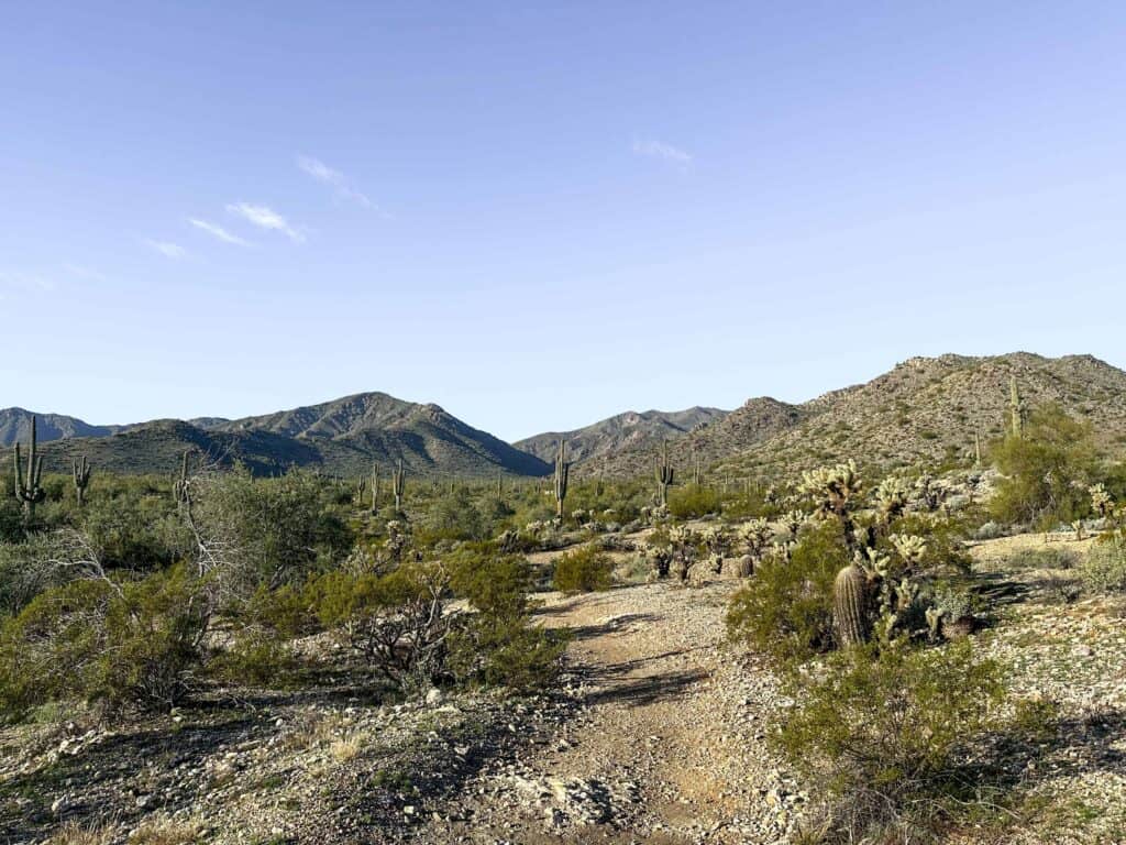
Altogether the Mule Deer Trail is 6.8 miles out and back (3.4 miles one way). There isn’t an official “end of trail” or destination, so feel free to hike as far as you’d like and then turn around. The trail leads you from the parking lots, up a little hill, then back down and through some beautiful vegetation. It skirts around the base of the main White Tank Mountains, staying relatively flat the entire time.
Along the way you’ll have beautiful views. Looking East you can see the Phoenix valley and other mountain ranges off in the distance, while looking West you see into the White Tank Mountains.
Eventually the trail will lead you past the Nature Center. Feel free to detour here and visit it, then hop back on Mule Deer! Just past the Nature Center the trail will cross one of the park’s main roads. I imagine many people turn around once they hit the road, but you can continue on for a little ways before the end of trail.
If you want to add distance to your hike and create a loop you could! Just take a look at the park trails ahead of time and bring a map with you. There are several interconnecting trails here where you can create your own experience!
Final Thoughts On The Mule Deer Trail

I was quite surprised on how much I liked the Mule Deer Trail! My mother-in-law mentioned she wanted to get out and begin hiking again so I chose this one for us to begin on. She hadn’t been very active or on a trail for years yet she conquered this one with ease.
The Mule Deer trail isn’t too rocky or elevated which makes it a great little trail for any activity. You don’t have to hike the entire 3.4 miles out and back if you don’t want to do 6.8 miles. Feel free to hike as much as you want, then turn around and return to your car.
Altogether we hiked 4.63 miles. I’m tempted to return and use it as a trail run next time!
More In Phoenix:
- Tom’s Thumb Trail in Scottsdale, AZ- all you need to know
- 9 Amazing Superstition Mountains Hikes for your Bucket List
- Hiking Black Mountain Trail in Cave Creek- What to expect
- Take a cruise with Lake Pleasant Cruises- One of the best Phoenix attractions
- Hike Pinnacle Peak Trail in Pinnacle Peak Park, Scottsdale
I’d love to hear from you!
Are you putting Mule Deer Trail in the White Tanks on your itinerary? Or have you hiked it before? Share in the comments below.