

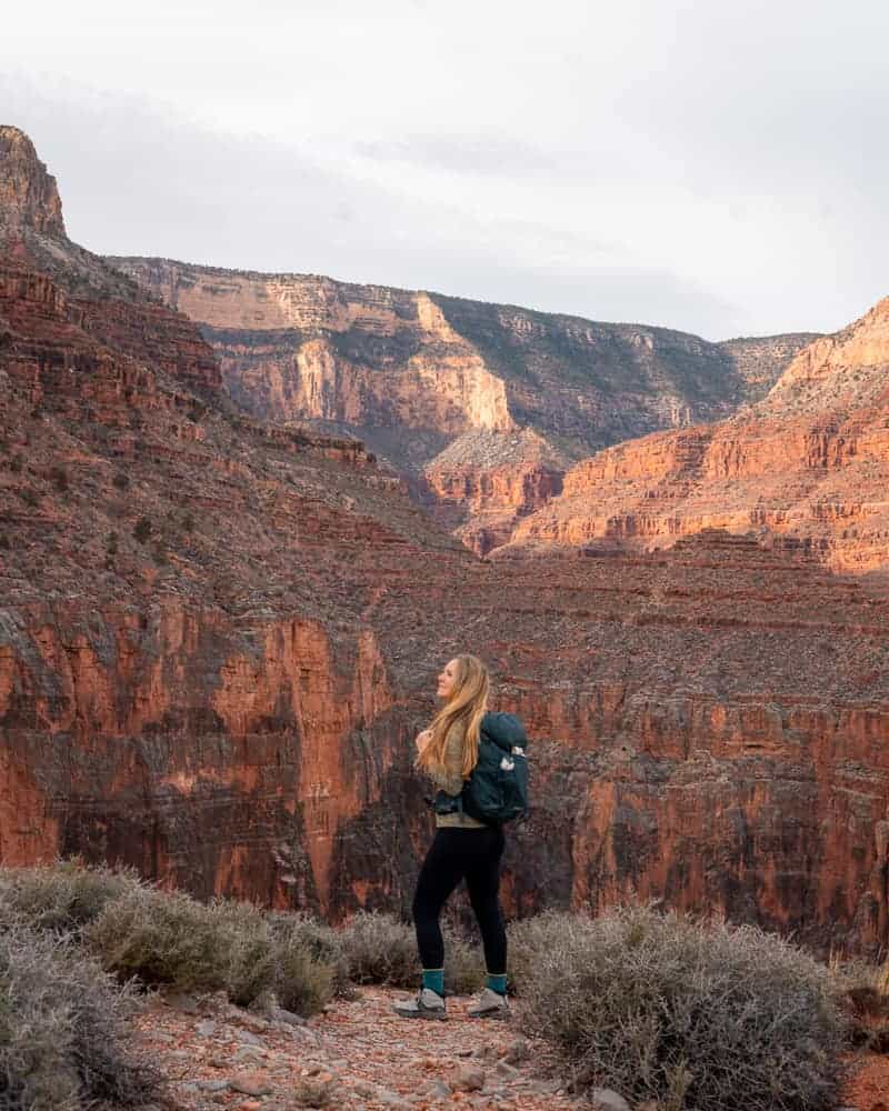
The Grand Canyon is one of the seven wonders of the world and if you plan on visiting, a hike into the canyon will fill you with the utmost appreciation for it’s awe-inspiring beauty.
Located on the Grand Canyon South Rim, the Hermit Trail is one of the lesser traveled trails that provides access to the Colorado River. Since it is not considered one of the park’s main ‘corridor trails’, the trail is not maintained and there are zero treated water stations along the way.
Your journey down Hermit Trail will be difficult, steep, yet extremely rewarding! While you don’t have to hike the entire trail to appreciate the Grand Canyon, reaching the Colorado River via Hermit Trail is an amazing experience! But, it should only be attempted by experienced hikers.
In this post I’m going to guide you through the beautiful stopping points along Hermit Trail for a shorter hike, as well as all of the details you need to know for hiking (or backpacking) rim to river: planning, parking, packing, and route details. I hope you’re ready for quite the adventure!
*Disclaimer: the below links may contain affiliate links, which means I may receive commissions if you choose to purchase through my links I provide (at no extra cost to you). Please see my disclosure for more info.
Stats: Hermit Trail To Hermit Rapids
- Hiking Distance | 17 miles RT
- Difficulty | Difficult & strenuous
- Elevation Gain | 4,690 feet
- Total Time | 8-12 hours, varies depending on fitness level.
- Permits/Fees | $35 Grand Canyon National Park entrance fee or National Parks Pass.
- Trailhead | Hermit Trailhead
- Road Conditions | 0.25 miles of well graded dirt road, 2WD okay.
- Dogs Allowed | No dogs allowed on trails within the park.
Hermit Trail Map

So, where does the Hermit Trail lead you? There are a few destination points along the way that are prefect for resting or turning around. But ultimately if you are trying to hike rim to river in a day, or are looking for a good backpacking trip, Hermit Rapids will likely be your destination.
If you’re not physically able to hike the full trail, that is OKAY! Doing so is extremely challenging and should not be attempted unless you are an experienced hiker and absolutely sure of your abilities.
Below is an overview of the distinct turnaround points along Hermit Trail.
| Destination | One-Way | Round Trip | Facilities |
| Santa Maria Spring | 2.0 mi | 4.0 mi | Trough of spring water, must filter. |
| Lookout Point | 3.7 mi | 7.4 mi | None |
| Breezy Point | 4.5 mi | 9 mi | None |
| Hermit Creek Campground | 6.9 mi | 13.8 mi | Restrooms- no paper. Filter water from creek. |
| Hermit Rapids | 8.5 mi | 17 mi | None. Filter water from river. |
Each of these points will be covered more in depth further in this guide. Let’s get started!
Try These Other Grand Canyon Rim To River Routes!
If you are feeling a little uneasy about Hermit Trail, I highly suggest trying one of these alternate rim to river routes first! They utilize the park’s main corridor trails so they’ll be maintained and have more water access. While they are still very difficult, they aren’t as rugged and difficult as Hermit Trail.
- How To Hike South Kaibab, Phantom Ranch, & Bright Angel In One Day
- Hiking The FULL Bright Angel Trail To Phantom Ranch
- Best Guide To Hiking The Full South Kaibab Trail In One Day
Getting To Hermit Trailhead

To reach Hermit Trailhead you’ll need to enter Grand Canyon National Park which has a $35 entrance fee, or you can use the National Parks Pass. If you plan on visiting a national park 3x within a year, the park pass it worth the investment!
Hermit Trail is located all the way at the end of Hermit Road on the South Rim. You’ll pass Hermits Rest on your right, and continue straight down a dirt road. This road loops at the trailhead and provides a good amount of parking for hikers and backpackers.
Can I Drive To Hermit Trailhead?

You can drive yourself to Hermit Trailhead during the months of December, January, and February. Unfortunately Hermit Road is only open to private vehicles during those months. Outside of those months you’ll have to utilize the park’s red shuttle route.
Having to utilize the shuttle definitely poses a logistical problem if you’re trying to start your hike at a certain time, and you have to be sure you’re back to the shuttle stop in time for the last shuttle!
If you miss the last shuttle you’ll be stuck having to hike roughly 7 miles down Hermit Road!
When To Hike Hermit Trail
Did you know the bottom of the Grand Canyon can be 10-20 degrees warmer than on the rim?!
Because of this, I highly advise hiking Hermit Trail during the cooler months: late winter, early spring, and late fall. Meaning February, March, late October, and November.
Check the South Rim’s high temperature for the day of your hike! If the high temperature is supposed to be 60 degrees, it will likely be 70-80 degrees down below. Given the strenuous nature of the hike and lack of water sources, I wouldn’t advise hiking in anything hotter than this.
If you plan on hiking rim to river you’ll also want to get an early start! I started 1 hour before sunrise (6:15 am at the end of February 2024) and am so glad that I did. This is a long hike and I wanted to make it out before sunset.
Never hike below the Grand Canyon rim during summer! It is extremely dangerous due to the strenuous activity paired with high temperatures. In my opinion mid May-September are too hot for a rim to river hike.
View this trail in 3D by visiting my Instagram reel below!
The Hike: Hermit Trail To Hermit Rapids

Ready to begin this stunning trail in the Grand Canyon? I sure hope so, because it is going to be quite the adventure, so stick with me here!
The beginning of Hermit Trail is surprisingly peaceful. You hike through a pine forest and the trail gradually decreases in elevation. Even the trail itself feels wide, not so rocky, and decently maintained. When I hiked in late February of 2024 there wasn’t any snow on the trail, but Bright Angel Trail had quite a bit in the first half mile.
After about 0.3 miles the trail becomes rocky, throws in a few switchbacks, and drastically drops in elevation. You’ll be descending almost 2,000 feet in the first 2 miles! This means when it comes time to climbing back out it is one of the most difficult parts, especially when you are already fatigued.


Along the way you’ll pass 2 trail junctions but they are marked with signs and very easy to follow! There is also a STUNNING spot to take photos, just off the trail to your left.
You’ll notice a short and faint trail that leads up to a small rock outcropping. This is where I stopped to take some photos and was blown away. If you make it all the way to Santa Maria Spring you’ll know you’ve missed this photo location, pictured below.

Santa Maria Spring
2 miles down, 4 miles round trip.

At 2 miles you’ll drop down to Santa Maria Spring, one of the destinations along Hermit Trail for day hikers.
Right off the side of the trail sits a stone rest house that covers two benches. This is a great place to take a rest and eat a snack!
Right next to the building there is a big trough that catches water from the natural spring. You can use this water to fill your supply if needed, but it must be treated by utilizing a filtration system. It also is never guaranteed that there will be water here!

Continuing past Santa Maria Spring, Hermit Trail becomes very pleasant for a short while. It turns to dirt, levels out, and hugs the canyon wall as it continues on.
This part of the trail was a much needed break while climbing out of the canyon! The canyon wall will provide shade during certain parts of the day, and the level trail provides your muscles a little break.
Eventually you’ll hike down another series of small switchbacks, and immediately after, you’ll see the next stop- Lookout Point.
Lookout Point
3.7 miles down, 7.4 round trip.

On the left of the trail, at about 3.7 miles in, there will be a short social trail that veers off towards a three tiered rock formation. This is called Lookout Point and is 0.1 mile off the main trail. Visiting this lookout will add 0.2 miles to your overall mileage.
I didn’t stop to visit this lookout during my hike since it didn’t look too enticing. I was also moving at a good pace so I didn’t want to stop. It seems like a great viewpoint though! I believe it would overlook Hermit Creek down below since it lines up perfectly with Hermit Creek Campground!
It also provides a great destination for day hikers who want to shorten their mileage!
Breezy Point
4.5 miles down, 9 miles round trip.

Not far beyond Lookout Point is Breezy Point, one spot I did choose to explore. It isn’t far off Hermit Trail and provides stunning views of the red canyon walls.
From Breezy Point to Hermit Creek Campground you’ll traverse an area called Cathedral Stairs. This is where things get interesting! Cathedral Stairs is a series of tight, steep switchbacks that feel never ending. They are also very rocky so be sure to watch your steps. This was my least favorite part of the entire hike!
After Cathedral Stairs you’ll pass by Cope Butte, another relenting portion of your hike. This area feels like it goes on forever as it is a steep section that doesn’t have switchbacks. The trail is also very rocky and requires some large steps to be traversed. On the way up this was the most challenging section to push through.
Once past Cope Butte you’ll hike upon the West Tonto Trail junction. Keep straight to continue on Hermit Trail and head to the campground!
Hermit Creek Campground
6.9 miles down, 13.8 round trip.


Technically you don’t have to visit Hermit Creek Campground in order to reach Hermit Rapids. However, I feel like exploring Hermit Creek near the campgrounds, then following it back to the main trail all the way to the rapids, was the best part of this hike overall!
I’m also going to let you in on a little secret. If you visit the campground area, be sure to hike upstream a little ways for two of the most impressive waterfalls in the area! Both are pictured below.


I found a nice pool of water below one of the falls and did a cold plunge (pictured above). It was ice cold but revived my already tired muscles!
Below is a close up of the area on my map. You can see the section where I hiked upstream.

After you enjoy the waterfalls and swimming holes near the campground, you’ll hike along the creek until it reaches the Colorado River. This section of the trail is insanely stunning and makes the entire hike worth the effort. It will make your overall milage for the day 17.8 miles, though!
You’ll cross the creek a few times, hike above it, and hike in it. Some basic route finding skills will be needed, but overall it is straightforward. There were some cairns that helped keep me on track, but you can never count on these always being there.

Download the Hermit Trail route on your GPS prior to beginning your hike! There were a few sections where it was easy to hop on a trail and head in the wrong direction, or miss the main trail while heading back from the rapids.
You can download my GPX track by subscribing below!
Hermit Rapids
8.5 miles down, 17 miles round trip.

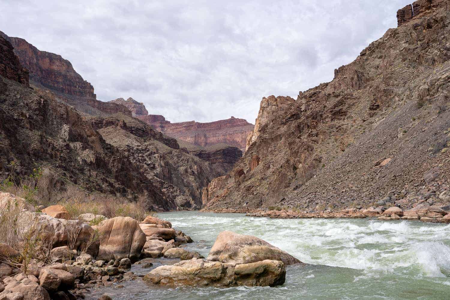
Reaching Hermit Rapids is a thrilling feeling, especially when they are flowing strongly! They are so loud you can hear them before you even see them.
Usually there is a beach and backpackers can camp here, but when I visited the water level was so high there were no spots to set up camp. Instead, I had to scramble around the large boulders lining the Colorado River to find a spot to sit for lunch.
You do not want to get in the water here! The current is powerful and deadly. On the plus side the views of the river flowing through the canyon walls are simply aw-inspiring. This is a beautiful portion of the river to be at!
The Climb Out
If you are hiking rim to river in a day you won’t want to spend too much time at the rapids for the hike out will take you longer than it did to get down.
The hike out is long, strenuous, and very steep. You’ll be climbing 4,690 feet! Be sure to replenish your water supply and eat plenty of snacks to provide your body enough fuel.
Tips For Hiking Hermit Trail To Hermit Rapids
- Download the trail to your GPS so you can check your location along the way. It can get confusing in parts!
- Know your limits and when to turn around if the hike is becoming too tiring or strenuous for you.
- During winter months the trail can have snow and/or ice. Pack your crampons just to be safe!
- Bring hiking poles to help relieve your joints on the relentless descent and ascent.
- Pack a water bottle so you can mix in electrolytes to stay hydrated.
- Have a Sawyer Filtration system with you to filter your water.
- Do not hike during hot temperatures for it will fatigue you and cause possible heat related illnesses.
- In my opinion mid-late February is the best time to hike Hermit Trail.
- Pack the 10 essentials.
- You may read reviews of a recent rockslide that requires scrambling over. Don’t worry, it isn’t hard. Just go straight across and it’ll take you three steps. No part of it is frightening!
More In The Grand Canyon:
- Desert View Drive- 5 Scenic Stops On Grand Canyon South Rim
- Grand Canyon Bike Rentals Are The Best Way To See South Rim
- EXACTLY How To Plan & Hike Rim To Rim, Grand Canyon
Final Thoughts On Hermit Trail
Despite the difficulty of this strenuous hike, Hermit Trail easily topped my top two favorite hikes in the Grand Canyon.
I’m not going to lie- when I was hiking back up to the rim I was cursing myself and questioning my sanity. I told myself I wasn’t going to do this trail again. Yet, as I write this, I’m already dreaming of returning and instead of Hermit Rapids, making Granite Rapids my destination!
The Grand Canyon is always difficult to conquer, and in my opinion that just adds to the overall feeling of accomplishment for completing a rim to river hike.
I hope this guide has helped you plan, or re-plan your Hermit Trail hike!
Thanks for your excellent and detailed report! I’ll be hiking the same trail in april.
Hi Pieter, thank you for reading! Happy to help. Hope you have a wonderful hike in April!